Hawaii Landforms
Geography 101 Lab
Writeup Instructions: For this lab, you will take a MULTIPLE CHOICE QUIZ. In the Submit Labs area, simply click the appropriate lab quiz, follow instructions, and answer the 20 multiple choice questions. All quizzes will be somewhat different because questions are randomly selected from a large data base. You can repeat the quiz if you wish; I will keep the highest grade.
This is an open book test with no time limit.
Purpose: This lab introduces some of Hawaii's basic landforms and helps you to recognize them visually.
The Hawaii Landforms Lab includes a combination original fluvial and coastal geomorphology lessons and resources provided by Volcano World, currently maintained at Oregon State University. On the quiz, you will be shown images of 20 of the following landforms, chosen at random. All you have to do is identify them. Before taking the quiz, be sure that you have gone through all of the material carefully and can recognize all of the landforms.
| Volcanic Landforms | Fluvial Landforms | Coastal Landforms |
A'a Lava |
Amphitheater-headed Valley |
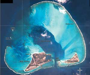
Atoll |
Volcanic Landforms
Review the volcanic landforms lessons provided by Volcano World for Hawaiian Volcanism. Click the links at the right for lessons on Large Scale Features, Vents, Lava Flows, and Lava Transport. Be sure to click the sub-menu links under each of these major topics.
Fluvial Landforms
Fluvial refers to the work of water, which is responsible for most of the erosional shaping of the surface of Hawaii's shield volcanoes. Geologists have identified a gradual erosion progression for Hawaiian mountains in youthful stages (A and B) and mature stages (C and D), as illustrated below (from Macdonald et al., 1983)
 |
 |
 |
||
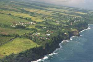
Hamakua coast - Stage A |
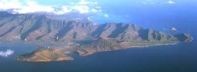
East Oahu - Stage C |
|||
 |
 |
|||
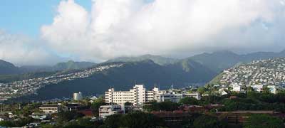
Koolau planezes - Stage B |
Southeast Kauai - Stage D |
 |
|
V-shaped valley |
 |
|
Rainbow Falls plunge pool |
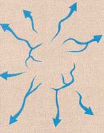
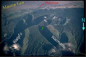
In the initial youthful stages (A and B), streams carve well spaced, steep-sided, V-shaped valleys separated by wide flat expanses of the original shield volcano surface such as seen along the Hamakua coast of the Big Island above. Notice the narrow stream channels identified by dark green strips of trees. On their path to the ocean, streams flow over lava rock with differing resistances to erosion, often forming stepped courses with plunge pools at the base of waterfalls. On volcanic islands, streams radiate outward from mountainous centers in a radial drainage pattern. As the topography matures, the upper reaches of stream-cut valleys may converge, with one valley becoming the dominant water conduit in a process called stream capture. In the image below, Waipio Valley has captured the headwaters of Waimanu Stream on the slopes of Kohala Volcano. The area between the valleys will eventually erode into a triangular shape. In stage B, aging valleys widen into the familiar amphitheater-headed valleys such as Manoa. As the valley heads widen and converge in the mountainous island interiors, they isolate triangular sections near the coast called planezes, as illustrated in B above and seen on the house-covered slopes above Honolulu. Notice how the houses rise up the smooth planeze of Waahila Ridge to a triangular apex, after which a narrow ridge divides the upper (and converging) valleys of Manoa and Palolo.
 |
 |
 |
 |
 |
||||
Radial drainage |
Stream capture in Kohala mountains |
Manoa amphitheater-headed valley |
Knife-edged ridges |
Koolau vertical valleys |
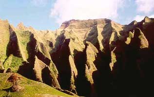
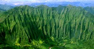
In the mature erosion stages (C and D above) the planezes wear completely away, such as seen in the east Oahu image above. As erosion continues, spectacular knife ridges form in the wet interiors separating "vertical valleys." The original valley walls eventually disappear leaving only the fluted valley headwalls and retreating ridges presiding over relatively flat terrain such as the Lihue area of southeast Kauai. As the islands flatten out, the erosional work of the ocean along the coastlines becomes a more dominant shaping force.
 Coastal Landforms
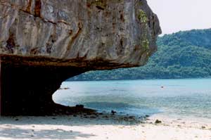
Hawaii's surrounding ocean hammers relentlessly at the coastline, carving away a bit of the islands with each wave until, ultimately, it completely erases the aerial basalt of extinct volcanoes. As wave erosion shrinks the islands, it creates distinctive landforms. Windward shores feel the brunt of the ocean's assault and here erosional forces work most quickly to plane away the rock, leaving a notched coastal shape, as shown in the diagram. Coastal landforms include both erosional (solid rock) and depositional features.
 |
 |
 |
|||
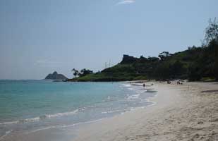
Headland at end of Kailua Beach |
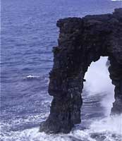
Holei sea arch |
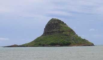
Mokoli'i sea stack |
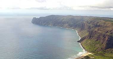
Erosional landforms are cut into the solid rock by wave action. A wave-cut nip forms at the shoreline under the most intense wave action. Anyone who has walked to the Toilet Bowl at Hanauma Bay has touched a wave-cut nip. The shoreline of Niihau (below) gives an excellent example of sea cliffs with an offshore wave-cut terrace, just visible through the clear ocean water. Occasionally, these platforms may become exposed, perhaps due to falling sea level, and form flat coastal plains of old coral reef. In the image below, you can clearly see the ancient sea cliffs inland that mark the old coastline of Mana plain, west Kauai. Because coastal rock formations differ in resistance to erosion, an exposed headland may form, jutting out from the retreating adjacent coastline. This focuses wave energy to undercut the rock behind the headland which may carve a sea arch, such as Holei in Volcanoes National Park. Small offshore islands, created by the collapse of a sea arch or simply isolation by erosion, are called sea stacks. Well-known sea stacks of off-shore Oahu include Mokoli'i (Chinaman's Hat) and the Mokuluas of Lanikai (visible behind the headland image above).
 |
 |
 |
||
Wave-cut nip |
Coastal plains on southwest Kauai |
Sea cliffs on Niihau |
 |
 |
||
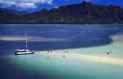
Kaneohe Bay sandbar |
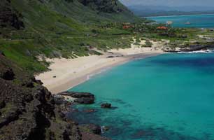
Headlands at Makapu'u beach |
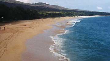
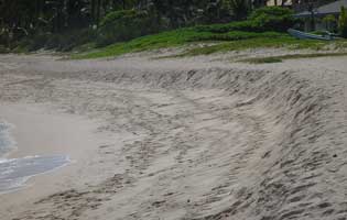
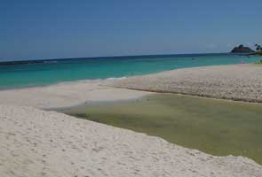
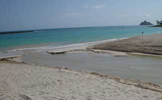
Erosion of the coastline pulverizes rock and coral into sand that accumulates into deposits both on land, such as beaches, and offshore, sometimes visible as sandbars. Hawaii's beaches change shape with the season and weather as sand moves both onshore and offshore and laterally with currents. In general, high wave energy gouges a steep beach face and moves sand offshore, while low wave energy forms a gently sloping beach face and moves sand back onto the beach. Beach shape changes continuously and often quickly under high waves, as shown by the temporarily steep face on normally smooth Kailua beach. Inland from the beach face, a high berm typically forms; the beach equivalent of transverse dunes found deserts. Individual beaches may be confined by rocky headlands with a high resistance to erosion as shown in the Makapu'u image. Where rivers empty into the ocean, sand may close the river channel completely forming a bay-mouth bar. The outgoing water filters slowly through the sand to escape to the ocean during normal conditions, but may open a channel to the ocean during periods of high stream flow.
 |
 |
 |
 |
|||
Berm of Big Beach, Maui |
wave-cut beach face, Kailua |
Baymouth bar, Kaelepulu stream |
Baymouth bar open after heavy rain |
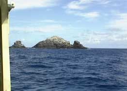
As the waves plane away exposed basalt, they create broad wave-cut terraces on which the reefs grow. In Hawaii, all of the reefs are classified as fringing reefs, even though in some areas, such as Kaneohe Bay, they may extend two miles offshore. As the aerial rock erodes over millions of years, it eventually shrinks to a few rocky pinnacles sitting on a submerged platform, such as the Gardener Pinnacles (below), Necker Island, and Nihoa Island northwest of Kauai, and then disappears completely. The reef continues to grow, however, on the broad flat platform left by erosion forming atolls, such as Midway and others in the northwest Hawaiian Islands. In Hawaii, the chain of atolls extends to about 30 degrees north latitude as shown in the map below. North of that, the water is too cold for corals to grow and the flat, coral-capped former high islands sink beneath the waves forever as guyots. The entire sequence is animated in the Life of an Island movie created by Bishop Museum.
 |
 |
 |
 |
|||
Maunalua Bay, fringing reef |
Gardner Pinnacles |
Midway atoll |
Life cycle of oceanic volcanic islands |
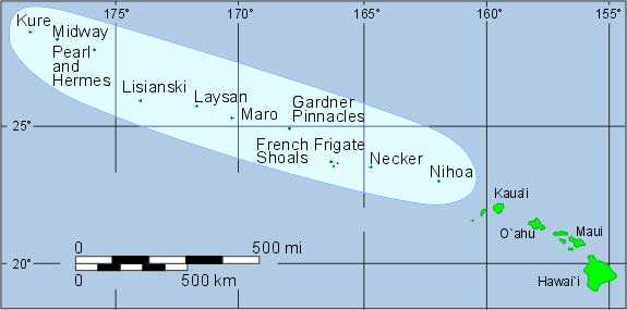 |
Northwest Hawaiian Islands are old rocky pinnacles and coral atolls |
Photo Credits
Most volcanic landform images from USGS
V-shaped valley, Waimanu, Big Island (http://www.webcom.com/trw/hawaii/contents.html)
Hamakua Coast (http://www.webcom.com/trw/hawaii/contents.html)
Stream Capture, Big Island (http://volcano.und.nodak.edu/vwdocs/hawaii_review/life_stages/post_alkalic/kohala1.html)
Planeze, East Honolulu (instructor)
Stage C, eastern Koolaus (http://soswcd.org/images2.htm)
Knife Ridge, windward Oahu (http://www.photolib.noaa.gov/coastline/coind9.htm)
Vertical Valley, windward Oahu (http://satftp.soest.hawaii.edu/space/hawaii/virtual.field.trips.html)
V Shapel Valley, Waimanu (http://polihale.com/display/60117/2)
Stage D, windward Oahu (http://satftp.soest.hawaii.edu/space/hawaii/virtual.field.trips.html)
Plunge Pool, Akaka (http://www.matuschek.net/vacation/hawaii2002/gallery/index.html)
Plunge Pool, Rainbow Falls (http://www.hawaiiweb.com/hawaii/html/sites/rainbow_falls.html)
Sea Cliffs, Niihau (http://polihale.com/display)
Sea Cliffs, Molokai (http://satftp.soest.hawaii.edu/space/hawaii/vfts/molokai/molokai.air.photographs.html
)
Sea Arch, Volcanoes NP (http://www.terragalleria.com/parks/np.hawaii-volcanoes.2.html)
Coastal Plain, Mana, Kauai (http://polihale.com/display)
Wave-cut Nip (instructor)
Beach (instructor)
Wave Face (instructor)
Sea Stack (instructor)
Bay-mouth Bar (instructor)
Berm, Big Beach, Maui (http://www.mauistore.com/picture_pages/big_beach_in_makena.htm)
Gardener Pinnicles (http://explorers.bishopmuseum.org/nwhi/picarch.shtml)
Midway Island (http://www.hawaiianatolls.org/maps/satimages.html)
Life Stages of Islands (http://www.hawaiianatolls.org/teachers/lesson_life_of_an_island.html)
Map (http://explorers.bishopmuseum.org/nwhi/)
References
Macdonald, G.A., Abbott, AT, Peterson, FL (1983) Volcanoes in the Sea,
2nd Ed., UH Press