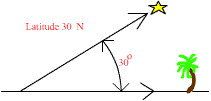
subtropics
midlatitude
The North Pole
The art of establishing and finding coordinate locations is ancient. Polynesian navigators had (and have) a deep understanding of coordinate locations and the navigation guides to move between them. (Dennis Kawaharada of the Polynesian Voyaging Society gives a summary of wayfinding techniques.) Rising and setting points of certain stars, their "houses", provide accurate bearings for navigation as do north-south lines that connect "meridian pairs," stars with the same celestial longitude. Latitude is determined by star positions in many ways. For example, in the northern hemisphere, the angle between the horizon and Polaris provides a close approximation of latitude. The angle at which stars rise and set also gives latitude in both hemispheres. You will become familiar with both of these methods in this exercise.
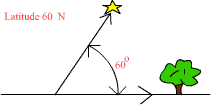
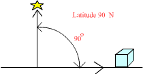
First, the star Polaris (meaning polar in Latin, also called the Pole Star, the North Star, Alpha Ursae Minoris, and Hoku-pa'a to the Hawaiians) remains in a seemingly fixed position in the sky within 2° of the North Celestial Pole. Because it lies in this position, latitude can be estimated by simply measuring the angle between an observer's horizon and the star itself, as shown in the diagrams below for several latitudes.
|
|
|
|
subtropics
|
midlatitude
|
The North Pole
|
Use the information above to answer the following questions.
24. If Polaris lies directly overhead (90° above the horizon),
what is your approximate latitude? What is the name commonly given to the latitude
where you are located?
25. If Polaris lies directly in line with the horizon, what is your approximate
latitude? What is the name commonly given to the latitude where you are located?
26. If the angle between Polaris and the horizon is 40°, what is your approximate
latitude?
27. If the angle between Polaris and the point directly overhead (called the
zenith point) is 20°, what is your approximate latitude?
Looking toward the East, an observer's latitude is simply the angle between a vertical line and the line followed by rising stars. The two simulators below illustrate the concept for both hemispheres.
|
SKY SIMULATOR
|
LATITUDE GUESSER
|
Practice entering different angles and hemispheres in
the Sky Simulator on the left until you understand the relationships involved.
Latitude
is the angle between the vertical line (marked east)
and the path made by rising stars. Then, try your skill at guessing your latitude
using the Latitude Guesser on the right. Just click Start New and estimate
your latitude (include which hemisphere, Southern or Northern). When you think
you
have the answer, click Answer for the correct latitude. Keep practicing until
you can estimate your latitude to within a few degrees. And remember, if a
navigator
missed their target by just one degree of latitude, they would be off by 69
miles. Show several of your guesses (including N or S) and the actual latitudes
in the questions below.
28. Latitude Guess ______________, Actual Latitude ______________________
29. Latitude Guess ______________, Actual Latitude ______________________
30. Latitude Guess ______________, Actual Latitude ______________________
31. Latitude Guess ______________, Actual Latitude ______________________
32. Latitude Guess ______________, Actual Latitude ______________________