Writeup Instructions: For this lab, simply answer the questions fully and directly. In your writeup, write each question number followed by the appropriate answer. Do not repeat the question wording in your writeup. Enter your answers under Lab Report 8 in the Submit Labs area. Do NOT email me your answers. I highly recommend that you record your answers using a word processing program, save, and then cut and paste into the answer area.
Purpose: Become familiar with the Hawaiian Islands' marine environment, use online resources for studying the ocean, and study basic data related to surf forecasts.
The Ocean Environment
The Hawaiian Islands are small land masses in a vast marine environment. The stability of this environment accounts for the stability in Hawaiian climate. For example:
Using the surface salinity maps from the Ocean Atlas of Hawai'i:
5. How does the salinity of the ocean surface vary between the Big Island and Kauai?
6. Where is the highest salinity shown on the map located (what latitude)?
7. Where is the lowest salinity?
8. The salinity of the surface depends on the balance between precipitation (lowers salinity) and evaporation (increases salinity). Based on this information, explain the salinity pattern shown on the map.
Using the surface current map from the Ocean Atlas of Hawai'i:
9. What is the dominant current direction in the vicinity of the Hawaiian Islands?
10. How do the Hawaiian Islands affect the currents downstream of the islands?
11. These eddies often cause upwelling which brings cold water to the surface in spots as shown in this typical image of surface temperatures. In this image, where is the circular cold water spot located (shown in blue)?
12. Look in the lee of Maui. Why do you think the water is so warm there (a model is shown in the Ocean Atlas)?
Waves and Surf
Open ocean swells that break on Hawaiian shores may be generated by storms occurring thousands of miles away. The size of the swell depends on the wind speed in the storm, the duration of the high wind, and the "fetch" or length of open ocean over which the wind blows in the direction of Hawai'i. The swells then slowly decrease in intensity with distance after leaving the storm. As they near the Hawaiian Islands, a network of buoys around the islands records their open ocean characteristics and this data becomes the basis for local surf forecasts.
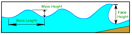
Basic Wave Relations
Ocean surface waves are described by wave height, wave length, and wave period. You can review the definitions of these and other terms using the Wave Simulator provided by the PBS Nature site. Browse through the lesson by clicking the numbers 1,2,3, and 4 at the bottom of the simulation. Use the information presented to answer the questions below:
13. In your own words, what is meant by "wave period?"
14. In normal wave action, which moves forward, the wave form or the water?
15. As a wave passes, water particles move in what geometric shape?
16. What causes normal surface waves to form?
17. What three things about the wind determine how big a wave will ultimately become?
Current Conditions
There are several ocean buoys scattered around the Hawaiian Islands that
help forecast incoming swells. Go to the NOAA
buoy website to see their locations. At the site, click on “51001” (the buoy is drifting north of Oahu) and "51004" (the
buoy south of 'Oahu) and scroll down to answer the following questions: NOTE: if a buoy is not working or missing information, just use data from the nearest working buoy.
18. What are the time and the date of the latest observation for each buoy?
19. What are the current wave heights (WVHT in feet) for each buoy?
20. What are the current dominant wave periods (DPD in seconds) for each buoy? If not available, scroll down and use swell period (SwP).
The global pattern of wave heights and directions are given for world oceans at a number of sites.
21. Using the global map of ocean wave heights given by Oceanweather (click on Hawaiian Islands area, the tall rectangle at the right center), what are the approximate significant wave heights near the Hawaiian Islands (wave heights are color coded, see legend at the bottom of the map)?
22. What is the dominant direction of waves in the Hawaiian Islands area (what direction are they coming from as shown by the arrows)?
23. What are the largest wave heights of waves that are moving toward the Hawaiian Islands (follow the arrows backwards)?
24. At what latitudes are the largest swells occurring around the world (click some of the other areas on the world map)?
There are also several near-shore "waverider buoys" that help show directional motion of wave trains. Data for these buoys is given at the SOEST buoy site.
Travel time to 'Oahu
Calculate the speed of the wave and approximate travel time to Waimea Bay (north shore of 'Oahu) from Buoy 51001 (assuming a north swell) and the speed and travel time to Ala Moana (south shore of 'Oahu) from Buoy 51004 (assuming a south swell) for waves with the dominant wave period (DPD recorded above) you recorded for the two buoys. Use the DPD from #20 above found at the NOAA buoy website. Assume that the distance from each buoy is 255 miles. NOTE: if a buoy is not working or missing information, just use data from the nearest working buoy.
Speed of the Wave (mph) = 1.7 x Dominant Wave Period (seconds)
Travel Time (hours) = Distance (miles) / Speed (mph)
Arrival time at shore = Time at buoy + Travel Time
Assume the distance is 255 miles for all calculations.
25. What is the speed of the wave using Buoy 51001 data?
26. What is the travel time for the wave at Buoy 51001 to reach Waimea Bay?
27. When would the swell occurring at Buoy 51001 recorded above arrive at Waimea Bay (assuming north swell)?
28. What is the speed of the wave using Buoy 51004 data?
29. What is the travel time for the wave at Buoy 51004 to reach Ala Moana?
30. When would the swell occurring at Buoy 51004 recorded above arrive at Ala Moana (assuming south swell)?
Show your work! Do not just write the answer, write the equation too. You can check your work approximately with these travel time tables (note that these tables may use different buoy numbers but calculations are based on 255 mile distance, so travel times should match).
Surf Forecast
This depends on the location, direction of the swell, bottom configuration and a host of other variables. The relationship between swell height and period, and surf height is not linear. In general, the longer the period the greater the effect of shoaling and wave refraction. In other words, 6 foot waves at the buoy might indicate 2 to 4 foot surf, but 20 foot waves at the buoy might produce a forecast exceeding 30 feet for some locations.
31. Give the date and the official surf forecast for the North and South facing shores of 'Oahu as given by the National Weather Service. Under Forecasts, click Marine and then Surf Forecast for Oahu.
32. How are the surf heights measured by the NWS (read text carefully)?
33. Give the date and the surf forecast for the North and South facing shores from Surf News Network. Scroll down to the Surf Report and list the HAW and FACE ranges for North and South for the same day as the National Weather Service forecast.
34. What is the difference (in feet) between the FACE and HAW (also called local scale) surf heights for this date from Surf News Network?
35. In your own words (maybe one sentence) describe how HAW surf heights are determined based in this explanation from the Surf News Network.
Recently there has been controversy regarding the reporting of wave heights. A popular surf forecast by Pat Caldwell was "terminated" by the National Weather Service (read the rational from the old web site.) The National Weather Service prefers the national standard for surf reporting, which is the full wave face height. Local reports often use 2/3 or 1/2 the face height, which often approximates the height of the back of a breaking swell. Here's an article available through the UH regarding standardizing wave height measurements
36. Give a brief account of your experiences with Hawai'i surf and near shore waters, or ocean experiences in other places.
37. Please tell me about how long it took you to complete this lab and what significant problems you had. Thanks.