WEATHER PATTERNS from MIGRATORY LOWS

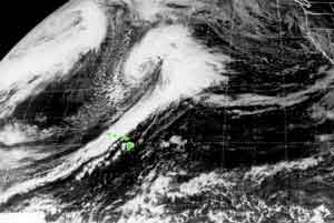
Cold Fronts: FORECAST: increasing cloudiness, decreasing pressure, winds shifting from southwesterly to northerly, temperature dropping, widespread rainfall locally heavy, chance of thunderstorms and flash flooding. Rapid weather changes are the hallmark of fronts. The front is a transition between air masses, so a typical sequence would be: warm air mass conditions, heavy weather at the transition, cold air mass conditions. In the warm sector (pink in the diagram below), an area would experience light winds from the south, humid conditions, and relatively clear skies. As the front sweeps past, the forced lifting of air could produce deep clouds and rainy weather. Some of Hawaii's (and elsewhere's) worst weather has been the result of a vigorous frontal passage. An example would the New Year's Eve flooding of 1987. Up to 20 inches of rain fell on parts of East Oahu in just a few hours. After the front, cold air mass (blue in the diagram below) conditions, dominated by a migratory High, prevail (see the clear area trailing to the left of the front in the satellite image?). Winds turn northerly, temperature drops, and skies clear.
Warm Fronts: FORECAST: Increasing cloudiness with a chance of light showers, winds turning southerly, with temperatures increasing. The difference in temperature between air masses at a warm front in the vicinity of Hawaii is generally very small and, thus, associated heavy weather is rare. Most warm fronts pass north of the islands, but if they do pass over, Hawaii may experience increased cloudiness and instability, followed by hot, humid weather, and southerly winds.
Exercise: In the diagram to the left, click on the Low pressure system, hold the mouse down and drag the system around to see how winds change depending on location.. To simulate the typical passage of a cold front, move the system from left to right keeping the warm front to the north of the islands. What is the wind direction and temperature before the cold front passes? How does the wind direction and temperature change after it passes? How would wind direction and temperature change if a warm front passed over the islands? (NOTE: blue is cold air, red is warm air. ALSO NOTE: the center of the Low does not pass south of the islands).
Shear Line: FORECAST: cloudy skies, widespread rainfall likely, highs in the upper 70's, lows in the upper 60's, variable winds. If the migratory Low is far away to the northeast, the long tail of the cold front may touch the islands bringing overcast skies and rainfall. Because the temperature contrast between air masses is minimal, however, shear lines seldom produce violent weather. If the distant low is over the West Coast of the mainland, it may bring miserable, wet weather to California and Oregon as tropical moisture is pumped east and north into the system. On the mainland, this configuration is called the "Hawaiian Express" or the "Pineapple Express" as the trailing end of the cold front is often in the vicinity of Hawaii.
