WEATHER PATTERNS dominated by HIGH PRESSURE
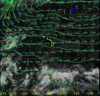
Normal (Dry) Trade Winds: FORECAST: sunny, mauka showers, trades 10-25, cool nights, highs in mid-80's, lows in mid 70's (yawn...). In Hawaii, dry trade winds are the most common weather pattern, especially in summer. A stationary High is generally parked to the north-northeast of the islands (officially called the East Pacific Ocean Subtropical High-pressure center, but generally shortened to simply: the Hawaiian High) producing the familiar northeast trade winds as shown in the above image. Winds generally average between 10 and 25 MPH, depending on the local pressure gradient and skies are clear with a few puffy cumulus clouds. Showers may fall in the mountains, especially later in the day when heating warms the surface, but the weather over the oceans, leeward areas, and low-elevation island areas, like West Molokai, is typically dry. Humidity generally feels comfortable as well, as trade wind turbulence mixes dry air downward into the surface air layer.
Exercise: In the diagram below, click on the rotating High, hold the mouse down and drag the system around to see how winds change depending on location. When the High is north of the islands, what is the wind direction in Hawaii? What is the wind direction when you drag the high to the east (E), south (S), and west (W) positions? When we get strong westerly winds, where is High pressure located?
Kona (Light and Variable) Weather: FORECAST: Better break out the fans, variable winds less than 10 mph, sea breeze conditions, clear skies in mornings, growing cloudiness in the afternoon with chance of locally heavy rain for interiors, highs in upper 80's, lows in low 70's, uncomfortable humidity. When the High pressure ridge moves directly over the islands, the pressure gradient is said to be "flat." No pressure gradient at the center of High pressure systems means no winds. Clear skies prevail. Wind direction shifts but is commonly southerly. This often brings vog from Kilauea over the other islands (and Hilo, too) producing hazy conditions. Because winds are light, sea and land breezes often become the dominant winds. On occasion, daytime heating can produce enough instability for heavy rain and even thunderstorms to form over island interiors. Light southerlies and no trades means no downward mixing of dry air and, thus, high humidity. NOTE: Kona Winds properly refers to light southwesterly, or leeward, winds.
Exercise: Place the High directly over the islands. What is the wind pattern like?
Wet Trades: FORECAST: Skies mostly cloudy, winds becoming northerly then northeasterly and strengthening to 15-30, frequent windward showers and leeward drizzle. Hawaii may experience wet trades when conditions are moderately unstable, perhaps when the inversion weakens under stationary high conditions. This also may happen under migratory High conditions following a cold front passage. The migratory high drives cool air from the north over warm ocean water near the Islands causing unstable conditions and increased rainfall. In general, the higher the wind speed, the greater the rainfall.
Exercise: Drag the High from left to right on a line even with the capital N (north) to simulate a migratory High following a cold front. How do the winds over Hawaii change direction as the High moves?