Historically, there have been numerous reports of high winds and stormy conditions in Hawaiian waters that appear to have been tropical cyclones. An example from the Big Island was the "Kohala Cyclone" of 1871. Plantation manager, D.D. Baldwin wrote:
'On Wednesday of last week a fearful tornado swept through the district, spreading desolation and ruin in its track, demolishing Mr. Wright's mill building and a large portion of the thatched houses in the district; throwing down our flume; uprooting large trees, and prostrating our cane fields.
"The wind commenced about 6 o'clock A.M. from the North, and rapidly rotating to the West and South, and increasing in fury, reached its climax about 9 AM when it suddenly lulled into a calm fearfully in contrast with the rain the storm had so rapidly wrought. The wind was accompanied with torrents of rain which raised the streams to an unprecedented height and swept away fences and trees."
While it is probable that many of these events were actually organized tropical cyclones, perhaps with hurricane intensity, the modern era of conclusive identification of hurricanes did not began until the tracking of Hurricane Hiki in 1950. Since 1970, definitive satellite coverage for Hawaiian waters has been available providing a complete catalog of all tropical cyclones near Hawai'i.
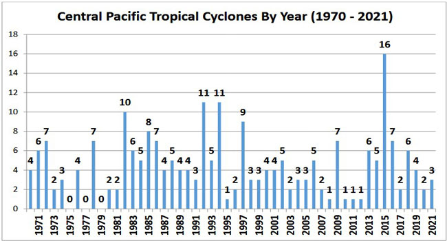
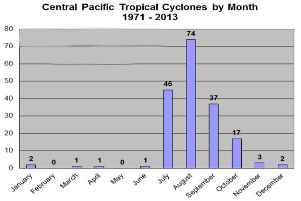
The frequency of tropical storms either entering or forming in the Central North Pacific Zone between 140° and 180° west longitude has varied greatly from year to year, from 0 to a maximum of 16 in 2015. On average, about five tropical cyclones form in this zone each year with 30% of these storms developing into hurricanes. The most common months for cyclones in this area are July, August, and September, but they have occurred in most months (see below).
It should be noted that the highest frequency of tropical cyclones in the Central North Pacific zone occurs during El Nino-Southern Oscillation (ENSO) years. ENSO is a Pacific- wide phenomenon during which ocean surface water warms in the Eastern Pacific and pressure systems in the South Pacific reverse or weaken. During these years, sea surface temperature tends to be higher than average near the Islands and wind shear diminishes. Both Iniki and 'Iwa struck Hawai'i during ENSO years
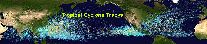
As noted in Chapter 6, environmental conditions in the Hawai'i region offer some protection from powerful storms. The ocean surface temperature is usually near or below 27° C, a threshold for hurricane formation and survival, and wind shear that saps a storm's energy is common over the islands. These conditions tend to weaken, deflect, or dissipate approaching storms. In the northern hemisphere tropical cyclone and hurricane track map below, you can see how these storms tend to stay south of the Hawai'i (red circle) or dissipate as they move toward the Islands.
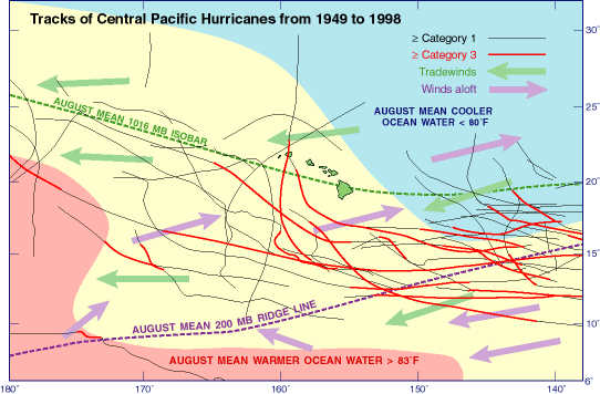
The dissipation of storms is even more evident in a closer view map (from Wikipedia) of the Central North Pacific zone. Look at the fading tracks of hurricanes approaching from the east. The map also shows how Hawai'i lies near the 27° C ocean surface temperature threshold in the warm month August and the wind shear resulting from surface tradewinds (green arrows) blowing in the opposite direction of the upper air winds (purple arrows). When the bottom of a storm moves one way and the top moves the other, the system gets blown apart and weakens.
Dot: August 1959
Dot swung northward after apparently forming in the East Pacific, traveling almost parallel to the Island chain, before passing directly over Kaua'i on the night of August 6. The storm was weakening as it neared the Islands, with maximum sustained winds over Kaua'i still exceeding 80 mph, which snapped trees and caused major agricultural damage, particularly to macadamia orchards. Flooding caused further damage to fields of pineapple and other crops. The yacht Esprit, sailed through the storm encountering, "black dark, heavy blinding rain, hurricane force wind, (and) sea increasing ..." before entering the eye where, "quite suddenly the weather cleared and the wind dropped to calm. A bright starlight sky overhead gave enough light to see the mountains, dark to the north, and towering ghostly white clouds nearby to the west..."
'Iwa: November 1982
'Iwa formed south of Hawai'i during one of the most severe ENSO years on record. The storm weakened as it moved north to the Island's latitude and curved northeast, passing just to the west of Kaua'i. This path exposed Kaua'i to the most severe section of the storm, sweeping the island with 80 mph winds and causing widespread damage estimated at $250 million. 'Iwa carried a broad reach, producing conditions over O'ahu severe enough to knock out power in Honolulu for several hours and cause major wind damage. The storm spurred counties to reevaluate building codes, with Kaua'i opting for higher standards of construction by requiring metal anchors for residential construction, for example.
Iniki: September 1992
Iniki was the fifth costliest natural disaster ever to strike the United States, with damages estimated at over $3 billion. Miraculously, only six deaths were connected to the storm. Like 'Iwa, Iniki formed south of Hawai'i during a strong ENSO episode. The storm wobbled northward toward the Islands, finally veering away from O'ahu and passing directly over Kaua'i near the height of its intensity. Over land, maximum sustained winds exceeded 140 mph, gusting to 175 mph, and reversed direction as the eye passed over the Island. Storm surge and overwash heavily damaged structures along the south coast. Over 1400 homes were destroyed during the passage of the hurricane and another 12,000 damaged. Damage was so extensive, it caused an insurance crisis in Hawai'i, prompting the State government to issue special hurricane insurance for homeowners.
Iselle: August 2014
Iselle grew into a powerful Category 4 hurricane and took aim at Hawai'i in early August, 2014. Like most of its predecessors, Iselle weakened as it approached the Islands eventually making landfall along the Kau coast on the Big Island just below hurricane strength. The storm remained powerful enough, however, to bring torrential rains, damaging surf and strong winds that destroyed crops, including over 1/2 of the state's papaya crop, and knocked down thousands of trees, particularly invasive albizia trees in the Puna District. Most of the storm damage was done by these falling trees, including knocking down power lines and blocking roads.