
The Nile River flows northward first through the new nation of South Sudan, then Sudan, then Egypt, before reaching the Mediterranean Sea. [Note: Egypt is covered adequately in the text pp. 462-474; the rest of Africa not so well, and it will be discussed more in these lessons.] The area where it flows through southern Egypt and Sudan was once known as Nubia, and as noted earlier, it had been settled by horticulturalists and cattle pastoralists, perhaps as early as 7,000 BC. The site of Nabta Playa, (see last unit lesson on First Farmers of Africa and Europe) where an elaborate chiefdom built megaliths and appeared to have deified cattle, was actually located in Nubia. [The traditional boundary between Nubia and Egypt was south of Thebes at the 1st cataract, where the Aswan Dam is currently located; see map below.] Though Nabta Playa, which was not actually on the Nile, was abandoned when the rainfall pattern shifted, the population moved closer to the Nile in both present day Egypt and Sudan. It is highly likely that the Nubian chiefdoms influenced the development of early chiefdoms and ultimately the early Egyptian states further north on the Nile.
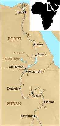
Nubia: Cataracts(rapids or boulder areas) of the Nile (1-6) indicated. Nubia began at the 1st cataract. [Photo public domain by Mark Dingemanse.]
The Nubian influence has led some historians to claim that Egypt was a black African kingdom, what is sometime referred to as the Afrocentrism school. Nubia certainly was a black kingdom, though Egypt almost certainly was not. Both were somewhat cosmopolitan states however, and certainly skin color differences meant much less to them than they do in the modern United States. There is evidence of a shared culture far south on the Nile, with Nubia only infrequently unified in one way or another with Egypt. More on this a bit later.
Egypt very early on traded with Nubian chiefdoms for gold, ivory, ebony, incense, exotic animals, and also for slaves. By 1750 BC, Nubia (also known as Kush) had developed into a centralized agrarian state, with its main city of Kerma (close to the third cataract in modern Sudan) being a densely populated urban area rivaling cities in Egypt. (As in Hawai'i, there is debate as to whether or not, or exactly when, Nubia became a political state as opposed to a very complex chiefdom; in point of fact that is probably more of a semantic debate then one with real scientific meaning--though you need to remember the definitions of both states and chiefdoms.) Certainly the rulers of Kerma were able to organize labor for monumental walls and other structures of mudbrick, and were buried in lavish tombs with possessions for an afterlife, as well as human sacrifices. By 1650 BC Kerma exerted control from 1st to the 4th or 5th Cataracts of the Nile. Within 100 years, Kerma defeated Egypt in battle, as Egypt attempted to extend its influence.
By 1500 BC, Egypt (during the New Kingdom,see text p. 471) invaded Nubia, destroying Kerma, and establishing control over most of Nubia. Egypt now controlled the sources of gold in Sudan, and became the main supplier for all the rival states around the Mediterranean. Egypt's control lasted until 1200 BC, when Nubia again became an independent powerful state, but one which had adopted much from Egyptian culture, including religious beliefs. While trade between the two continued, Nubia's power increased to such an extent that in 730 BC the Nubian King Piye conquered Egypt, and became the first of the so called black pharaohs who ruled Egypt for most of the next 100 years as the 25th dynasty.
You are required to read the recent National Geographic article on The Black Pharaohs. After you read the article, it is highly recommended that you also view the brief video "Race in Ancient Egypt", and view the "Photo Gallery." Links to both are found on each page of the required article on "The Black Pharaohs".
Ultimately, Egypt was temporarily conquered by Assyria, and the Nubian pharaohs no longer ruled. For Egypt, it was the beginning of more foreign control, as the Assyrians were followed by the Persians and Greeks, and ultimately Rome. In Nubia, power was now centered on Meroe, a city south of Kerma, between the 5th and 6th cataracts and some 200 miles northeast of the present Sudan capitol of Khartoum (see map above).
Meroe preserved many of Egypt's customs, but also developed their own form of writing. Initially they used Egyptian hieroglyphs, though later they developed an alphabetic script with 23 different signs. They continued to bury their kings in pyramids; as a result, there are more pyramids in Sudan than in Egypt.
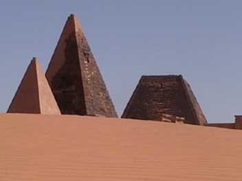
Pyramids at Meroe [Public domain photo]
Archaeologically Meroe is poorly known, and its language has not been deciphered. It is known that it was a state, with class stratification and as many as 70 generations of kings and queens. Meroe was also known for its skilled iron metallurgy, which provided them with weapons used to support a large army. Meroe also had craftsmen in ceramics, and in bronze.
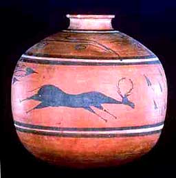

Nubian Ceramic (left) and Bronze pots from Meroe (ca.100 BC)
The Greek Herodotus wrote about reports he had heard of the magnificent city of Meroe, but he himself did not go there. There are also accounts that the Persians and later Alexander the Great were interested in conquering Meroe, but once again they never actually expanded out of Egypt. After Rome conquered Egypt in 30 BC, the Romans mounted a campaign against Meroe, and eventually defeated them. However, Rome did not occupy Meroe, and the two kingdoms continued to trade. Eventually however Meroe was defeated by the nearby kingdom of Aksum, and came under their control by 350 AD.
Aksum (also called Askum, Axum or the Axumite Empire), with its major city of Adulis, was located on the coast of the Red Sea, in present-day Ethiopia and Eritrea, with Yemen across the Sea on the Arabian Peninsula. Early Homo erectus, and later the first Homo sapiens, probably crossed initially into Asia just south of Adulis. By the time of dynastic Egypt, the area of Aksum was already a center of commerce, and was known in Egypt as the land of Punt. Aksum is identified with the Biblical Queen of Sheba (ca. 1,000 BC), and there is also a story that, after Jerusalem was sacked by the Babylonians, the Ark of the Covenant (containing the tablets inscribed with the Ten Commandments) was taken to Aksum. Still, little is known archaeologically even today, and the earliest records are those of Greece and Rome, who report that Aksum was a thriving kingdom by 100 AD.

Aksum
Adulis at one time was one of the most important port cities in Africa, as it was part of the major trade route between India, Arabia, and Africa. As Mesopotamia became less important, new trade routes used the Red Sea rather than the Persian Gulf, and a camel caravan route was established to the north that bypassed the Nile Valley. Like other Aksum cities, Adulis was also extremely cosmopolitan, with Nubian, Jewish, Christian, and even Buddhist minorities established.
With a rich agricultural base (primarily irrigated crops of the grain teff), Aksum became rich from its control of trade; gold and ivory from Sudan, as well as every commodity carried by the Greek, Roman and Indian merchants. Aksum also produced iron, ceramic and glass artifacts, and minted its own coins of gold, silver, and bronze. Common people tended to use bars of iron as currency.
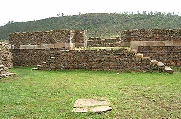
Ruins of Palace in Aksum, Ethiopia [Creative Commons]
The Aksum upper class lived in multi-storied palaces (see above), and were often buried under granite stele, or tall columns,that were carved to resemble those palaces. Some were over 100 feet tall, and 119 of them still survive. The burials under the stele were in brick chambers or catacombs. Though looted long ago, grave goods originally included gold, silver, and bronze objects, glass goblets and flasks, iron weapons, and multiple ceramic jars and pots,the remains of which have been excavated by archaeologists.
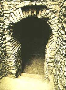
Entrance to the antechamber of the Tomb of the Brick Arches; inside are two similar doorways (18 feet tall) leading to two burial chambers. The burials were 25 feet underground.
At its height Aksum controlled much of the eastern part of Africa, from southern Egypt to the Omo River in southern Ethiopia, and probably also part of the southern Arabian peninsula. After 400 AD, the Aksum royalty at least became Christian, making Aksum one of the first Christian states in the world. With Christianity, the cross appeared on Aksum coinage. At about 1000 AD, Aksum was supposedly conquered by a non-Christian kingdom to the south, perhaps led by a warrior queen known as Gudit. Though Aksum eventually reestablished its independence, its importance had already declined, probably in part due to the expansion of Islam, which took control of trade routes, and in part due to over-farming and climatic change. Ultimately however, Aksum is the historical beginning of Ethiopia, which was the only African state not to eventually fall to a European power in the post-1500 world.