
Western Africa eventually developed agrarian states which rivaled those in eastern Africa. These early states developed out of complex chiefdoms which had developed in the area shortly after horticulture became prevalent. One of the earliest was the city of Jenne-Jeno, located on the Niger River in present day Mali. The area was first occupied around 200 BC, by horticultural and pastoral peoples who had iron tools. The Niger River floodplain turned out to be an excellent area to grow African rice (a different species than the rice domesticated in eastern Asia), as well as African millet, and sorghum. The people also raised domesticated cattle, sheep and goats. By 750 AD Jenne-jene had become established as one of the earliest trade centers, importing gold, iron ore, and stone from further south, and exporting rice, fish, and fish oil. In addition, the gold from the south was exported to Timbuktu (see Kingdom of Ghana, below) via the river, then via camel entered the major trade routes across the Sahara. At its height around 800AD, Jenne-jeno probably had a population of 20,000 people, and was recognized as an important trade center. The spread of Islam into the area during the 1100-1200s, the conversion in 1180 of Jenne-jeno's leader to Islam, and an increasingly dry climate, led to the decline of the city; much of its population probably moved to a new city established by Muslim rulers, at nearby Jenne. For more information, click here (not required) and see your text pp. 492-495.
Another early kingdom was the Kingdom of Ghana, first mentioned by an Arab historian in 833 AD. Located in parts of the modern countries of Mauritania, Mali, and Senegal . It probably owed its existence to the introduction of the domesticated dromedary (one-humped) camel to the area, which allowed the establishment of trade routes across the Sahara. [Dromedaries were first domesticated ca. 2,500-3,000 BC in their native Arabia; though present in Nubia by 900 BC, they did not become common in the western Sahara until later.] Introduced into the area ca. 750 AD, the dromedary camel allowed states along the Mediterranean to easily acquire the west Africa resources of gold, silver, ivory, salt, iron, and other desirable items, sometimes through Jenne-jeno (Djenne on the maps below), as noted above.
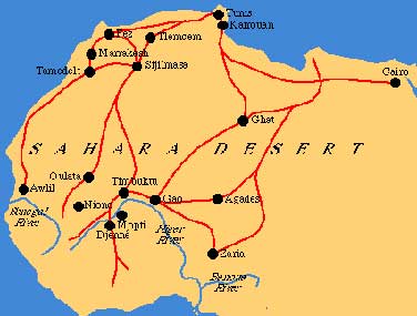
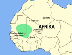
Trade Routes Across the Sahara (left); Ghana Kingdom (right)
The Kingdom of Ghana was not in the present-day nation of Ghana, but acquired its name because its hereditary king was called the Ghana. Ghana was a matrilineal kingdom, meaning that descent was traced through females only; while kings were male, a king could not leave the throne to his own son, but rather had to leave it to his sister's son.
The major urban area of the kingdom was a city called Koumbi Saleh, which at one time had upwards of 30,000 residents. Actually divided into two areas, the king and his court lived in one area, in houses of stone and wood, while commoners lived in houses of wood and clay. At one point an Arab historian reported that the King commanded an army of 200,000 soldiers, 40,000 of whom were armed with bows and arrows. Certainly Ghana subjugated its neighboring chiefdoms and small states, and the tribute or taxes paid by the defeated areas (a form of stratified redistributive exchange) helped support the kingdom.
The main economic base however was the trade in gold, salt, copper, and other items. The gold shipped from Ghana came from mines that were an 18 day journey to the south, near the source of the Senegal River. All gold nuggets belonged to the King, though it is reported that the people could keep the gold dust. Supposedly, the King owned a nugget so big he could tether his horse to it.
While Ghana existed during the spread of Islam across northern Africa after the death of the Prophet Mohammed in AD 632, the rulers of the Kingdom did not convert to Islam. Ghana did not develop a written language, so the accounts of Ghana are from Muslim historians, most belong to the Almoravids, which was a Muslim group originating in southern Mauritania that seized power and ruled north Africa, moving into Spain by the late 1000's. Ghana was already growing weaker as population expanded and much of the land was overgrazed, unable to support the population. A Muslim religious movement known as Sanhaja resulted in many of Ghana's neighbors engaging in a jihad or holy war against Ghana, and the capital city was captured in 1076. After a period of confusion and warfare among the chiefdoms and small states in the area, the Kingdom of Mali became the dominant political force in western Africa.
Centered in the modern nation of Mali, the Kingdom also included much of Mauritania and Senegal,as well as parts of modern Guinea Bissau, Sierra Leone and Guinea. The Mali or Manden (Mandinka) had long been a small state on the borders of the Ghana Kingdom, and were at one point a province of Ghana. Over a century after Ghana's fall however, Mali expanded, conquering the territory of its former ruler and at one point controlling an area the size of western Europe.
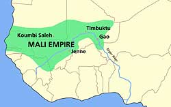
Map of Mali Empire (1350 AD) [Wikimedia Commons]
According to one story, Mali was founded by a man named Sundjata (Sudiata), who had once been a royal slave and magician among the Soso, the people who had taken over much of the Ghana Kingdom. Sundjata was actually the son of an earlier ruler, but had long been exiled. After seizing the major areas along the Niger River where gold was traded, Sundjata was able to monopolize the trade, which became the basis for his kingdom. Eventually at least three major gold mines were within its borders, and all gold went immediately into the royal treasury. Copper and salt were also mined in the northern part of the Kingdom, and traded both within and without.
The Mali Kingdom maintained a full-time army of some 100,000 soldiers, with reportedly 10,000 of them mounted cavalry.
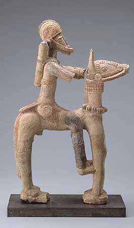
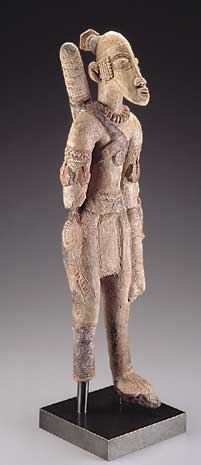
Mali ceramic figurines (each about 25 inches high) excavated near Djenne on Niger River, 14th century
Mali was from the beginning a Muslim kingdom, and its most famous ruler was Mansa Musa, who made an extraordinary hajj, or pilgrimage, to Mecca between 1324-25. He was accompanied by 100 camel-loads of gold, each weighing some 300 pounds. In addition he was attended by several thousand of his subjects, 500 slaves who each carried a 4 lb. gold staff, and his senior wife (who brought 500 of her own attendants.) He reportedly spent so much gold in Egypt that he depressed its value for several years afterwards. Mansa Musa brought back to Mali an Arabic library, a number of religious scholars, and the architect al-Sahkili, who built a great palace, and mosques at Timbuktu and Gao. As a result, in the 15th and 16th centuries, these areas became the cultural centers of western Africa, more important than those of northern Africa. Among other things, Mansa Musa's hajj brought the area the attention of the entire Muslim world, as well as that of Europe.
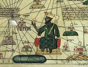
Spanish Map of 1395, with Mansa Musa holding a gold nugget
While Mansa Musa had brought peace and prosperity to his kingdom, after his death in 1337 its power began to decline. Small states to the south and north seized portions of the kingdom, including the city of Timbuktu. Eventually, the city-state of Gao, which Mansa Musa had subjugated, expanded into the powerful Songhai Kingdom, which quickly gained power over its former ruler.
The Songhai (Songhay) were originally a fishing and trading people centered on the Niger River, who had moved upstream around 800 AD and established themselves at Gao. Conquered at one point by Mali, by 1464 a warrior hero (in oral tradition) named Sunni Ali initiated a military conquest that greatly expanded his rule, conquering the states of Timbuktu and Jenne by the 1470's. Eventually Songhai rule extended over some portions of the former kingdoms of Ghana and Mali, and extended eastward into modern Niger and south into Burkina Faso.
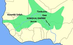
Greatest extent of the Songhai Empire ca. 1500 AD
The Songhai established an Islamic state that ultimately was larger and richer than that of the Mali kingdom which proceeded it. While most people were small farmers, the class stratification system more resembled a caste system, with separate castes for metal workers, carpenters, and fishermen. At the bottom were slaves, who as in all early states were primarily war captives. The upper class and the rulers monopolized the trans-Sahara trade, which was still primarily gold and ivory, as well as slaves. The upper class was Muslim, and Islamic culture dominated the urban areas, though most of the lower class continued to follow traditional religions. The vast empire, encompassing hundreds of different cultures and languages, required an efficient administrative system, a professional bureaucracy, and an system of judges who ruled according to Islamic law.
Both the size of the empire and external events combined to weaken Songhai in the period after 1500. European expansion down the coast of Africa, and the European discovery of gold-producing cultures in the Americas, made the trade routes across the Sahara less important to the Mediterranean and Europe. By 1591, the weakened kingdom was conquered by Morocco to the north.
Far to the south of Aksum, and shortly after its fall, two east African complex chiefdoms developed, with megalithic architecture. The earliest is known as the Mapungubwe, located in South Africa; the second is called the Karanga "Kingdom", or better known as Great Zimbabwe, located in the present modern nation of Zimbabwe. (See also text pp. 496-500) Again, one could debate if either ever became a state, or if they remained powerful chiefdoms; neither appears to have developed a written language.
By 400-500 AD, farmers with sheep, goats, millet and sorghum, as well as iron, had moved south of present day Zimbabwe and into South Africa, displacing the original foragers (ancestors of the modern day San) and pushing them further south and west. Archaeologists have excavated small villages containing iron arrowheads, beads, razors and rings, as well as a few copper artifacts and various handmade ceramics. Stone querns and grindstones were also found, indicating the importance of grains. Cattle were introduced into the area (from the north) by the 9th or 10th century AD, and bananas were brought in by Indonesian traders at approximately the same time. As happened in so many areas, horticultural/pastoral tribes developed the traits of chiefdoms in many areas, and began competing. The first powerful chiefdom/incipient state to develop was where the Shashe and Limpopo Rivers unite, and form the border of three countries: Botswana, South Africa and Zimbabwe. This is sometimes called the Mapungubwe Kingdom. The site of Mapungubwe itself became an early trade center, and evidence of social stratification includes various gold items in burials, including a gold rhinoceros. (Click here for pictures and more information.)
By 1250 AD, another chiefdom to the north, the Karanga, began to dominate the area, and their chiefs began to build large and complex stone enclosures and buildings. Spread out over an area of some 200 miles, the largest of these is the complex called the Great Zimbabwe.
One of the largest of the structures at Great Zimbabwe is called the Great Enclosure, and has walls as high as 36 feet, 16 feet wide, and extending some 820 feet. It is the largest ancient structure south of the Sahara Desert. The structure and its surrounding walls are built of nearby granite blocks, some finely cut, while some are very rough. Natural boulders in the landscape were sometimes incorporated. In one portion of Great Zimbabwe, eight sculptures of birds were found, with human lips for beaks and five-toed feet, carved out of soapstone. The birds had once been mounted on three foot high columns, but their arrangement can no longer be determined. Their purpose is also unknown, though they may have been symbols of authority.
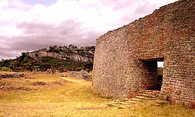
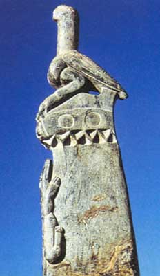
Portion of the ruins at Zimbabwe, and one of the soapstone birds (the birds averaged 16" high) [For more pictures of the architecture of Zimbabwe, click here. Also check the text pp. 496-500]
Little is actually known of the culture, as there was no written language and relatively little oral tradition preserved. The people were farmers and cattle herders, but the immediate environment of Zimbabwe was not the best for either endeavor. Still, as many as 18,000 people may have once lived in the immediate vicinity of Great Zimbabwe. It is possible that the chiefs here controlled a trade in ivory and gold with the east coast of Africa, where traders from India and the Arabian peninsula had already initiated exchanges for these and other items. Certain areas of Great Zimbabwe seem to indicate specialized crafts of bronze and iron, while other areas show large numbers of spindle whorls, indicating that cotton textiles were woven at Great Zimbabwe. Persian and Chinese pottery, glass from the Mediterranean area, and cowrie shells from the Indian Ocean are found in one hoard at Zimbabwe, and were probably prestige items to indicate rank. Iron gongs, hoes, and seashells were also found, items historically associated with chiefly authority.
Zimbabwe was at the height of its power from 1350-1450 AD. After that, it gradually lost power to chiefdoms to the north, where copper was more plentiful and where the Zambezi River provided a better trade route. The Portuguese reached the southern tip of Africa in 1487, and by 1498 had used an east African guide to cross the Indian Ocean to India. They subsequently established a fort on the east coast of Africa in an attempt to control the trade in gold. The Great Zimbabwe was totally abandoned shortly thereafter. When Europeans first saw the ruins, they speculated that the Great Zimbabwe must have been built by an earlier European invasion, since black Africans, they believed, could not have built such megalithic monuments. (This of course is similar to the European reaction to the Mississippian and Hopewell monuments in North America.) Archaeological excavations in the early 1900's established both the antiquity of the ruins, and the identify of their builders. For a brief article on Zimbabwe archaeology, with a couple more pictures to enlarge, click here.