THE NATURAL ENVIRONMENT
Geography 101
ToC
HEAT
Albedo
Greenhouse
Balance
Global
Local
Local Temperature
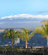 |
On a global scale, temperature differences from place to place depend largely on latitude and proximity to oceans or large lakes. On a local scale, however, elevation determines the temperature pattern. This is most evident in the highest mountains, such as Mauna Kea, which might be covered with snow while Hilo, at sea level, enjoys its usual tropical weather.
|
|
|
BOX 1 |
Elevation
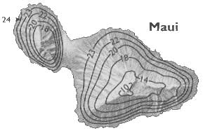
Have you ever driven or hiked up a mountain? It gets cooler as you go higher. As noted earlier, temperature in the troposphere decreases with height at about 6.5° C per kilometer (3.6° F per 1000 feet). The effect is less noticeable during the daylight hours when the sun heats the mountain surface, but is quite obvious at night. Consider the map of average annual temperatures for Maui below (given in °C). The average decreases from around 24° C (75° F) at sea level, to less than 10° C (50° F) at the summit of Haleakala at 3055 m (10,023 feet).
An extremely important climate control on Hawaiian weather involves another aspect of the air temperature profile: a temperature inversion. An inversion is a layer in the atmosphere in which temperature increases (not decreases) with height. In Hawai'i, this commonly occurs at about 1800 to 2400 meters (6000 to 8000 feet), as illustrated by the temperature profile below. This means that if you drive up Haleakala on a typical trade wind day holding a thermometer out the window of your car, the temperature will decrease between sea level and about 2000 meters (6500 feet) elevation, then increase for 600 m (2000 feet) or so, then resume decreasing with height again. You will have measured what is commonly referred to as the trade wind inversion.
 |
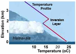 |
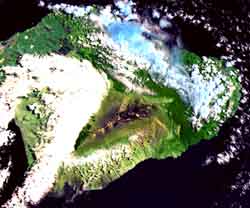
You will also notice that the temperature starts increasing above the top of the cloud layer. The images above illustrate this. The satellite photo shows Haleakala, East Maui, on a typical trade wind day with the inversion present. Notice how the summit (triangular center of the image) rises above the cloud tops that mark the inversion layer at about 2100 m (7000 feet), near the 14° C isotherm in the temperature map. The presence of the trade wind inversion influences many aspects of Hawaiian climate, including: 1) limiting cloud height and causing flat cloud decks to form, 2) limiting the amount of rainfall the islands receive, 3) reducing relative humidity to a level humans find comfortable at sea level, and 4) producing dry air and clear skies at the highest elevations.
Daily and Annual Pattern
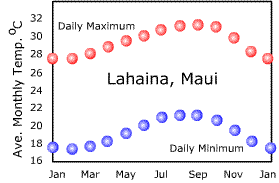
Look at the Maui temperature map again: what area averages the highest temperatures on Maui? The name of that location, Lahaina, meaning "cruel sun" in Hawaiian, explains why. The sunnier leeward sides generally have higher temperatures during the daytime than windward areas, where clouds and onshore breezes of ocean-cooled air help to reduce daytime temperatures
At night, the opposite occurs. Clear skies at leeward sites let longwave radiation escape to space, which cools the surface. Clouds over windward areas, on the other hand, trap longwave radiation, keeping nights warm. Also, the steadying influence on the onshore breezes keeps nighttime temperatures relatively warm. This results in a greater daily temperature range at leeward areas than at windward areas. So, if you prefer cooler nights for sleeping, choose a leeward site, but if you prefer cooler daytimes for working outside, choose a windward site.
To summarize, cloud cover tends to reduce the daily temperature range by increasing minimum temperatures and decreasing maximum temperatures. Under clear skies, full sunlight can reach the surface producing hotter daytimes and terrestrial radiation to space cools the surface causing colder nighttimes.
The graphs illustrate differences in daily maximum and minimum temperatures between a windward site (Lihue) and a leeward site (Lahaina). Notice the much greater daily range at leeward Lahaina. Notice also, that nighttime temperatures at Lihue are considerably warmer than at Lahaina, even though the city is much further north.
 |
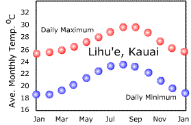 |
The graphs also illustrate the old adage, "Night is the winter of the tropics." Can you see why? Notice that the annual temperature range (warmest minus coldest month) is less than the daily temperature range (daily maximum minus daily minimum), especially for Lahaina.
One more note on local temperatures: Daytime temperatures generally peak at around 2 pm, about 2 hours after the maximum sunlight intensity. At night, the coolest hour is just before dawn because the ground will continue to cool until the Sun returns to warm it.