THE NATURAL ENVIRONMENT
Geography 101
ToC
WATER
Cycle
Balance
Water In
Water Out
Soil
Classify
Soil Water Balance: Water In
Rainfall
|
|
BOX 1 |
Precipitation
is generally the only source of water to the surface. The distribution of precipitation, therefore, is the most important,
 and least controllable, of all the variables
in the Soil Water Balance. Because of this, it is probably
the most commonly measured climatological variable in the world.
Hawai'i is no exception. In fact, because rainfall varies so much over short distances, Hawai'i has one of the densest rainfall monitoring networks in the world. I'm sure everyone has stood on a sunny beach, looked toward the mountains and seen rain. Measuring the rainfall at the beach, then, tells you very little about the amount of rain in the mountains. You have to monitor rainfall at the beach, in the mountains and at representative places in between to accurately map its distribution.
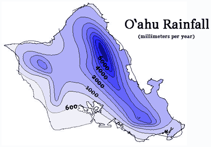
 Based on long term records from hundreds of rainfall monitoring stations, accurate rainfall maps have been produced for all of the Islands. The
O'ahu rainfall distribution in the image illustrates features common throughout Hawai'i. Rainfall at sea level is near the open ocean value
of about 600 mm (24 inches) per year. Because
of orographic lifting (discussed in Chapter
6 -> Lifting) rainfall
increases by a factor of 10 or more in the mountains, to over 7000 mm (276 inches) per year in the case of O'ahu.
High rainfall in mountainous areas provides the major input to the Islands' surface water balance. Because of their importance to Hawaiian hydrology, many mountain watershed areas are designated as water conservation districts and protected from development by state law. Disturbance of these high rainfall areas could alter the water balance and reduce the Islands' groundwater supplies.
Irrigation
 In
some areas, artificially watering the surface through
irrigation can be a significant source of water.
At one time, irrigation was quite important on sugar cane land in Hawai'i, as
this crop demands plenty of water. Some of Hawai'i's
largest
early
construction
 projects
were aimed at scooping high-quality water from the mountains and delivering
it to cane land. Tunnels, such as the Waiahole Ditch on O'ahu, were drilled
into mountains. Flumes
were built that drained surface water from streams and delivered it long
distances, such as Hamakua Ditch on the Big Island (shown in the image)
and East Maui Ditch on Maui. Most of these flumes and ditches are still
in operation today. The continued diversion of water is highly controversial,
however, as various parties fight
over whether
to have the ditches closed and the natural stream flows restored, and, if not, then
who gets to use water delivered by ditch and tunnel systems.
With the demise of sugar, irrigation input to agricultural land has been greatly reduced. Pineapple, for example, requires little or no irrigation. Irrigation is a growing component for another land use though: residential housing. Watering lawns and parks can contribute to the overall Water In component of the soil water balance, but is a net loss to the system through runoff and evaporation.
Fog Drip
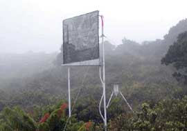
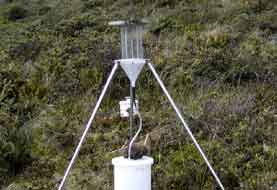
Finally, it should be noted that, in some upper-mountain areas in Hawai'i, interception of cloud water by plants, also called fog drip, can be a significant source of water to the surface. Cloud droplets collide with plant leaves, where the water accumulates and either drips directly to the surface or flows down the stem to the ground. On the upper slopes of Mauna Loa, for example, near the tree line, cloud water interception from sea breeze clouds provides an important source of water for native vegetation, such as the mamane tree. At higher elevations on Lana'i, tall-growing Cook Island pines were planted to "milk" water from passing clouds by intercepting droplets and dripping the accumulated water to the surface. On leeward Haleakala, Maui, a large screen mesh was constructed to study whether enough cloud water could be collected to support residential occupation in the area. Cloud water catchment is practiced in many other parts of the world as well, notably the arid coast of Chile where screens funnel fog water onto the roots of grapes and other crops.
The images show how cloud water interception can be measured. In both of the instruments, a collector, either a mesh screen or wire "harp," simulates a tiny tree canopy. The collected water drains into a reservoir where it can be measured. The research site at the left is located in Haleakala National Park on Maui and the one on the right is in Volcanoes National Park on the Big Island.
 |
 |