THE NATURAL ENVIRONMENT
Geography 101
ToC
VALLEYS
Landslides
Patterns
Erode
Deposit
Hawai'i
Fluvial Landforms by Erosion
|
|
BOX 1 |
Fluvial (water-related) processes create landforms both by erosion of the solid Earth and by deposition of the material broken loose and carried downstream. As mentioned earlier, the energy for erosion by water comes from sunlight. Sunlight energy evaporates water from the surface and drives winds that lift it to higher elevations where it returns to the surface as precipitation. The work of erosion is powered by that potential energy as water moves downhill on its journey back to the ocean.
When streams flow over the surface, they break down solid material in many ways. First, hydraulic action, the force of the water itself, attacks weakness in the bedrock and pries loose mineral bits. Second, the material carried along by the stream itself rolls and bounces along the surface loosening rock by abrasion. Third, chemical reactions in the water dissolve material and further erode the bedrock.
 All
of this loosened material, called sediment, is then transported downstream,
some dissolved in solution (called dissolved load),
some suspended in the water giving it a muddy color (called suspended
load), and the larger
pieces bouncing along the streambed (bed load). Have
you ever stood in a fast moving stream? You can feel the
bed load crashing
against your ankles. That continual pummeling is very effective at wearing
away solid bedrock and carving river valleys.
All
of this loosened material, called sediment, is then transported downstream,
some dissolved in solution (called dissolved load),
some suspended in the water giving it a muddy color (called suspended
load), and the larger
pieces bouncing along the streambed (bed load). Have
you ever stood in a fast moving stream? You can feel the
bed load crashing
against your ankles. That continual pummeling is very effective at wearing
away solid bedrock and carving river valleys.
The shape of landforms created by streams, and the characteristics of the streams themselves, depend greatly on the steepness of the gradient. In general, streams follow a typical longitudinal profile with steep gradients in their mountainous upper reaches and diminishing steepness (flatter terrain) in the lower reaches as the stream nears sea level.
 The
fastest erosion occurs near the stream head, where the
gradient is steep, the water flows rapidly, and there is little sediment
load for the stream to carry. Slower, or no, erosion
takes places along the flatter areas in the lower reaches of the stream
where the gradient
is slight, the water flows slowly, and most of the stream's energy is
used to carry the higher sediment load.
The
fastest erosion occurs near the stream head, where the
gradient is steep, the water flows rapidly, and there is little sediment
load for the stream to carry. Slower, or no, erosion
takes places along the flatter areas in the lower reaches of the stream
where the gradient
is slight, the water flows slowly, and most of the stream's energy is
used to carry the higher sediment load.
 In
the upper reaches of the streams, rapid erosion carves V-shaped
valleys. In extremely steep, young mountains the V-shaped valleys
may give a wild appearance to the terrain called feral relief,
as shown in the photograph of the high Andes. Typically in high mountains,
streams flow in straight channels and
organize into parallel drainage patterns.
In
the upper reaches of the streams, rapid erosion carves V-shaped
valleys. In extremely steep, young mountains the V-shaped valleys
may give a wild appearance to the terrain called feral relief,
as shown in the photograph of the high Andes. Typically in high mountains,
streams flow in straight channels and
organize into parallel drainage patterns.

 Toward
the lower reaches of the river, the gradient is less steep and streams
form meandering channels that wander back and forth
widening their valleys into flat-bottomed floodplains.
The meanders continuously move as the river cuts into its banks
on the outside of the meander curve, producing a steep cutbank.
As the meander extends in the direction of the cutbank, point
bars form
on the inside of the curved channel.
Toward
the lower reaches of the river, the gradient is less steep and streams
form meandering channels that wander back and forth
widening their valleys into flat-bottomed floodplains.
The meanders continuously move as the river cuts into its banks
on the outside of the meander curve, producing a steep cutbank.
As the meander extends in the direction of the cutbank, point
bars form
on the inside of the curved channel.
 Eventually,
as the meander becomes larger and more exaggerated, it will be cut off
by the formation of a new, shorter
section of channel, stranding a small body of water called an oxbow
lake. The oxbow lake eventually fills with sediment and vegetation
leaving only a meander scar.
Eventually,
as the meander becomes larger and more exaggerated, it will be cut off
by the formation of a new, shorter
section of channel, stranding a small body of water called an oxbow
lake. The oxbow lake eventually fills with sediment and vegetation
leaving only a meander scar.
 In
addition to straight and meandering channels, a third pattern forms when
a streambed is choked with sediment, typically from glacial meltwater. When the sediment load is greater than the stream's
ability to move it, the runoff
intertwines along the constantly changing streambed in a braided
channel.
In
addition to straight and meandering channels, a third pattern forms when
a streambed is choked with sediment, typically from glacial meltwater. When the sediment load is greater than the stream's
ability to move it, the runoff
intertwines along the constantly changing streambed in a braided
channel.
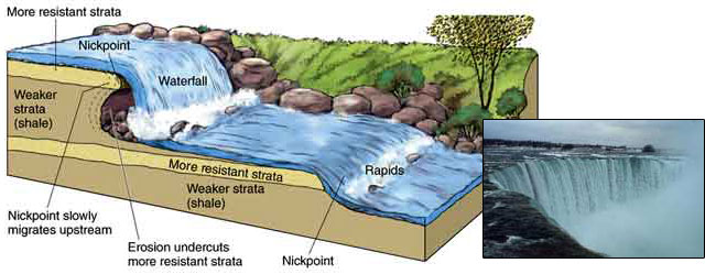
One final fluvial landform created by erosion that should be mentioned is a nickpoint. Nickpoints are breaks in the stream gradient where either waterfalls or steep rapids form. This happens in areas where bedrock consists of layers with different resistances to erosion, as shown below. At waterfalls, tumbling water excavates softer rock at the base, eventually leading to a continual series of small collapses by the more resistant surface rock. In this way, the nickpoint moves slowly upstream. Perhaps the most famous nickpoint is Niagara Falls, which is moving upstream at about 1.2 meters (4 feet) per year.