THE NATURAL ENVIRONMENT
Geography 101
ToC
VALLEYS
Landslides
Patterns
Erode
Deposit
Hawai'i
Stream Patterns
|
|
BOX 1 |
Landslides are simply a response to gravity. Most material, however, is carried or pushed by some erosive agent, such as running water, moving ice, or blowing wind. As noted earlier, all of these erosive processes are exogenic, meaning that they are powered by sunlight.
Running water does more erosional work than any other exogenic force and it produces most of the fine detail carved into mountains. The work of water in shaping the landscape (called fluvial processes) begins with erosion. Erosion refers to breaking loose and removing solid material from the surface. This loose and dissolved material is then transported downstream and deposited. This sequence of erosion, transport, and deposition applies to the other exogenic processes as well.
 So,
how does running water derive its energy from sunlight? It begins with
evaporation when the sunlight energy is absorbed by water vapor.
Then, winds, driven by sunlight energy, carry
water vapor into the mountains
where it condenses and returns to the surface as precipitation. Thus,
liquid water gains elevation and distance, evaporating from oceans and condensing
in mountains, through events driven by sunlight energy. The energy
gained by increased elevation, called potential energy in physics, is expended as water runs downhill on its
return to the ocean, eroding, transporting, and depositing sediment
as it moves. (Remember the hydrologic cycle? Chapter
7 -> Cycle)
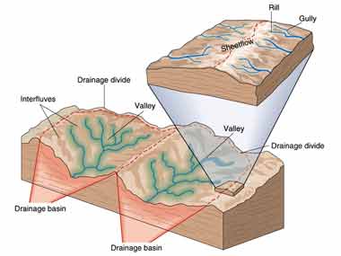
The study of fluvial processes focuses on individual streams and networks of streams. Each stream derives its water from a unique drainage basin. As the name implies, any rain falling in a stream's drainage basin area can eventually drain downhill and become water flow for that particular stream. Mountain ridges, or divides, separate drainage basins. The ridge of the Ko'olau mountains, on O'ahu, provides a very clear example of a divide that separates the drainage basins of streams flowing to the windward and leeward sides. Perhaps the most famous divide is North America's Continental Divide, which separates drainage basins whose water eventually flows into the Atlantic and Pacific Oceans.
Drainage Patterns
 As
networks of streams develop, the valleys they carve often reveal the
underlying geologic structure by forming distinct drainage
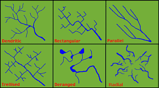
patterns. The most common pattern is random branching called
a dendritic drainage pattern. This pattern occurs frequently
in nature. Look at the branching of veins in a leaf, for
example, or the capillaries in living tissue.
 Other
patterns form when the underlying geologic structure forces streams to
flow in certain
ways. The trellis pattern, for example, forms in folded
mountains like the Appalachians in North America. The streams are forced
to travel in
relatively straight, parallel lines down the anticlinal valleys (see Chapter
10 -> Folding). At intervals, the streams cut through the ridges
to form water
gaps.
Water gaps frequently become important corridors for the movement of
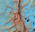
people. The Delaware Water Gap, shown in the photograph, is
lined with highways today and was influential in determining early
American settlement, travel, and commerce patterns.
 A
parallel pattern forms in young, steep terrain where streams
do not have the opportunity to migrate sideways. Fracturing and faulting of the landscape, which forces
streams into right angle turns, causes the rectangular pattern. A deranged pattern forms
in very new terrain or older areas that have been disturbed. Most of
present-day Canada, for example, was scraped and
excavated by continental ice sheets as
recently
as 10,000 years ago. In these areas, more organized geometric patterns
have not yet developed and many deranged stream networks can be found.
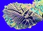
The most common pattern in Hawai'i is radial drainage. This occurs where streams radiate outward from an isolated mountain peak, as shown in the radar image of West Maui. Most volcanic islands have this pattern.
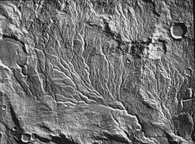
Finally, although Earth is the only planet known to have liquid water at the surface, we have recently learned that water or runny mud may have carved part of the early landscape of Mars. Surface mapping showed that Mars has ancient dendritic drainage patterns, as shown in the image. Because this pattern is only known to form by rainfall and runoff, the image suggests that Mars had precipitation long ago. Today, water still exists on Mars, although it is frozen into solid ice beneath the surface.
