THE NATURAL ENVIRONMENT
Geography 101
ToC
VALLEYS
Landslides
Patterns
Erode
Deposit
Hawai'i
Fluvial Landforms in Hawai'i
|
|
BOX 1 |
As with other places, running water does most of the work of erosion in Hawai'i.
Fluvial erosion features are least pronounced in active volcanic areas because lava flows continually resurface the mountain shields, filling in low spots and keeping the surface relatively smooth. In addition, basalt lava flows are highly porous allowing most, and sometimes all, rainfall to infiltrate into the ground, limiting surface-shaping runoff. On the Big Island for example, no permanent streams enter the ocean between Hilo and South Point on the windward side, or between South Point and Kawaihae on the leeward side. Nonetheless, even ephemeral (short-lived) streams carve into the basalt fairly efficiently and water flows are the main force of surface erosion in Hawaiian mountains.
 As
lava events decrease, the erosional stage in the life
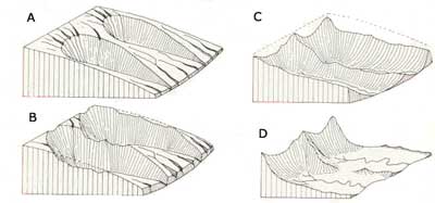
cycle of Hawaiian mountains begins. Ephemeral and permanent streams cut rapidly into the smooth
shield, creating
deep valleys separated by
wide,
flat
slopes as shown in A below. The Hamakua coast, on the
Big Island, provides an excellent example of this early stage of erosion.
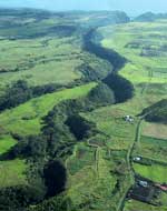
In the photograph, you can see broad slopes
of
the
original Mauna Kea shield incised by a narrow valley.
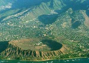
As erosion continues, valleys widen and deepen farther and farther inland. As these deep valleys tap groundwater, the rate of erosion increases at the headwall and base of the valley sidewalls. This creates wide valley heads called amphitheater-headed valleys, such as Palolo Valley on O'ahu, directly inland from Diamond Head (see photograph). Several things cause steepness in the valley walls. First, tall waterfalls continually undercut their bases causing collapses that maintain steep valley heads and cause them to move farther inland, rather like nickpoints we discussed earlier. Second, groundwater seeps out at the base of valley walls, undercutting and hastening erosion and widening of the valley floor. Third, the old lava flow layers that the Islands are built of have differing resistances to erosion. Rapid erosion of the softer lower layers causes undercutting, collapse, and steepening of the valley walls.
 Because
Hawaiian volcanoes have radial drainage patterns, the heads of adjacent
valleys eventually grow together and merge far inland, as shown in B. As
the valley heads join, a narrow ridge forms between them
leaving a triangular
wedge of the original shield volcano surface called a planeze.
The slopes covered
with houses
above
East Honolulu are excellent examples
of this type of formation. Look closely
at the developed
slopes of Maunalani Heights (right) and St. Louis Heights (left) in
the photograph and you can clearly see the house-covered, triangular
shapes ending
in
knife-edged
ridges where the amphitheater heads of valleys have merged. Many of
the narrow ridges at the end of planezes in Honolulu are used as
hiking trails
to
the Ko'olau
crest.
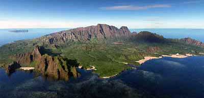
Eventually, the triangular planezes wear completely away leaving only a narrow ridge separating widening valleys, as shown in C above. Continued erosion removes even this remnant ridge, producing relatively flat plains near sea level, and tall, steep palis, or cliffs, toward the Island's interior, as shown in D above and in the computer-generated image of East Kaua'i (Lihue area) below.
