THE NATURAL ENVIRONMENT
Geography 101
ToC
WIND
Forces
Motion
Global
Local
Local Winds
|
|
BOX 1 |
Global winds travel hundreds, even thousands, of kilometers.
Within these vast prevailing wind belts, many, many smaller wind
systems intrude, most of them driven by local heating and cooling of
the surface.
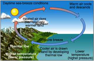
Consider the diagrams below. During the daytime, the sun heats the land surface. Remember that water surfaces tend to stay about the same temperature both day and night. So, during the daytime, land becomes warmer than the nearby water surface. This causes a relatively low pressure system with rising air to form over land and with higher pressure and sinking air over water setting in motion a small version of the planetary Hadley cell. The local wind blows from the higher pressure over the ocean toward lower pressure over land. Because this surface wind blows from the sea, it is called a sea breeze. In general, these circulations are too small to be influenced significantly by Coriolis.
 |
 |
Daytime Sea Breeze (onshore) |
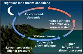
Nighttime Land Breeze (offshore) |
The opposite occurs at night. Land cools to a lower
temperature than the ocean surface, forming relatively higher pressure,
and the circulation reverses. The nighttime wind blows away from land,
forming a land breeze. This reversal of land and sea
breezes occurs almost every day in some areas, where it can dominate the
local wind pattern.
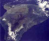
Consider the image of the Big Island, taken on a calm day. The southern (Ka'u district) and western (Kona district) flanks of Mauna Loa in the foreground have clouds forming on mountain slopes under a developing sea breeze. Anyone who has been to Kona has seen clouds forming over the inland slopes in late morning as the sea breeze gains strength. Notice the clouds do not rise to the top of the mountain, but are capped at the inversion level of around 1800 to 2400 meters (6000 to 8000 feet) elevation.
The sea breeze/land breeze circulation cycles daily on the leeward slopes of the Big Island. It commonly forms on the leeward slopes of other islands as well, especially on calm days. When the trade winds are absent or light, clouds may darken the skies of central O'ahu in late afternoon, occasionally even producing thunder, as sea breezes from north and south shores converge. Windward slopes also experience these thermal winds. In Hilo, for example, a cool land breeze blows out to sea virtually every night of the year.
Topographic Variations
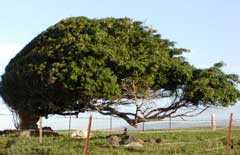
Another source of local wind patterns important in Hawai'i is the shape of the Islands themselves. Wind funneling through channels between islands is one of the most obvious effects. Look at the image below. The Big Island creates a huge "bow wave" (1) cloud as it blocks the prevailing tradewind airflow. (See the semi-circular cloud pattern?) As air streams around the Big Island, it funnels between Maui and Hawai'i, accelerating in speed, and forming the infamous rough conditions of the 'Alenuihaha ("great billows smashing") channel. Many places in Hawai'i are noted for high winds caused by topographic acceleration, such as the Pali Lookout and Kahuku Point on O'ahu, and of course, at South Point, Big Island where powerful winds are so regular that tree crowns grow downwind of their trunks, as shown in the photo below.
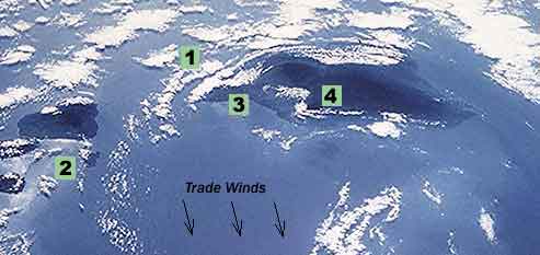
Other topography-induced wind features are evident in the image. See the line of clouds stretching downwind from southwest ridge of Haleakala, East Maui (2)? This cloud street forms as air moving north and south of the mountain converges on the leeward side, producing enough lift to cause clouds to form. A similar cloud street often forms downwind of the East Moloka'i mountains. Another local wind feature of leeward Haleakala (not visible in the image) is the Maui vortex. This is simply a circular eddy that sometimes produces a ring of clouds near the town of Pukalani ("hole in the sky").
Also, look at the sharp edge of the clouds over the Kohala mountains (3), especially in the saddle near the town of Waimea. Here, the air stream, under normal trade winds, reverses its cloud-forming, upslope motion and begins traveling downhill toward Kawaihae and the leeward coast. Under certain atmospheric conditions, this downslope wind may accelerate, creating extremely high gusts at the coast. These katabatic winds can be thought of as a kind of dry, upside-down thunderstorm.
Finally, also notice the S-shaped band of sea breeze clouds forming as air moves inland during daytime heating of the Big Island's leeward slopes (4).
Tree deformation at South Point, Big Island due to strong winds. |
 |