THE NATURAL ENVIRONMENT
Geography 101
ToC
WIND
Forces
Motion
Global
Local
Global Winds
|
|
BOX 1 |
At the most fundamental level, the global winds are set in motion by differential heating of Earth's surface by sunlight, i.e. the tropics are warm and polar areas cold. This differential heating gives rise to pressure differences and, consequently, to the pressure gradient force that compels air to move. Ultimately, as we saw earlier, the moving air redistributes heat from areas of surplus to areas of deficit.
 Remember
the vertical motion of air at High and Low pressure centers described
in the previous section, Motion? At the equator,
the warm surface causes low pressure and rising air.
At the poles, cold
air produces high pressure and sinking air. If Earth
did not rotate, this would describe the global circulation. Air would
rise at the equator,
flow at high altitude to the Poles, then sink and return to
the equator along the surface forming two gigantic circulation cells.
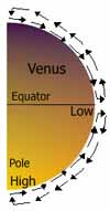
On planets like Venus, with negligible Coriolis force due to very slow rotation this is, in fact, what happens.
Global Pressure
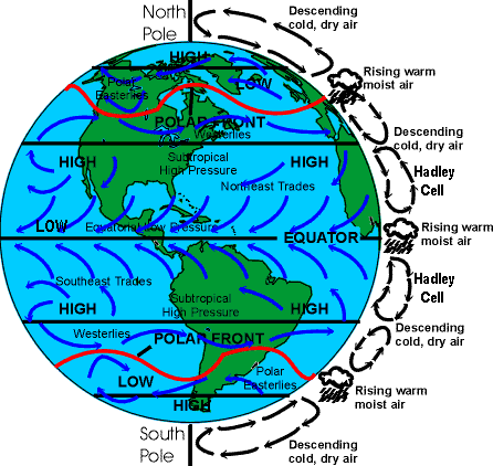
On Earth, however, Coriolis makes the situation more complicated. Air rises near the Equator, but rather than flowing all the way to the poles, Coriolis deflection produces sinking air at about 30° north and south latitudes as shown on the right side of the diagram below. This vertical motion in the tropics is so well defined that it has a name: the Hadley Cell. Rising air in the Hadley cell along the equator produces deep clouds, thunderstorms, and rain in a band of low pressure called the Intertropical Convergence Zone (ITCZ). Sinking air near 30° latitude causes high pressure areas called the subtropical highs. The highs produce clear skies and calm winds in a latitude band sometimes called the Horse Latitudes, which lie just north of the Hawaiian Islands and dominate Hawaiian weather.
Coriolis makes the air flow at higher latitudes even more complicated, but in general air flows out of the subtropical highs poleward along the surface then rises again at the Polar Front, which wobbles between 50° and 70° latitude. At the polar front, air rises, producing cloudy skies in a band of bad weather sometimes called the Subpolar Low.
 At
the highest latitudes, circulation is similar to the Hadley cell, except
much smaller. Air sinks over the poles, where Polar High pressure,
clear skies, and cold air dominate, then flows equatorward and rises again at the
Polar Front.
These large circulation cells produce global pressure bands in latitude zones as shown in the accompanying diagram as HIGH (30° latitude and the poles) and LOW (equator and 50-70° latitude). The surface pressure bands not only determine the climate at their location, but also drive the vast global surface winds. Studying the diagram will help you, not only in this class, but in understanding the weather wherever you travel in the world.
Global Winds
The diagram above shows two idealized views of air motion, the vertical cross-section shown on the right and the horizontal winds drawn over the image of Earth. Look at the very center near the word "Equator." Notice high pressure is to the north and low pressure is at the equator itself. Remember the rules regarding air motion in relation to pressure differences from the Motion section? Imagine standing on the high pressure area in the northern hemisphere looking equatorward and holding out your right arm. The PGF sets air in motion from you toward the equatorial low. The moving air is then deflected in the direction your arm points, to the right, by Coriolis. That motion forms the northeast trade winds as shown in the diagram. Now do the same for the southern hemisphere. Imagine standing on the high in the South Pacific, and looking north toward the equator, holding out your left arm this time. Air is deflected by Coriolis to the left, in the direction your arm is pointing, forming the southeast trade winds. The trade winds, so-named because of their dependability for sailing ships, are usually very reliable and cover nearly one half of Earth's surface. Trade wind weather is generally dry and sunny because of the subtropical High pressure influence. Areas near the equator lie in a low pressure zone (remember the ITCZ from the Global Pressure section above?) where winds are generally light or calm, a condition that mariners term the doldrums.
 |
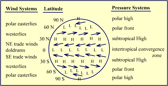
Summary of Global Wind and Pressure Belts |
(This is a good place to note how winds are named: winds are named for the direction they come from. So, northeast trade winds come from the northeast, westerly winds come from the west, sea breezes come from the sea, valley breezes come from the valley, and so on.)
|
|
BOX 2 |
Now apply the same reasoning to the winds between the subtropical highs and the polar front, or subpolar lows. Air flows from high to low pressure and Coriolis deflection produces westerly winds in both the northern and southern hemispheres between about 30° and 60° latitude. Westerly winds tend to shift direction much more than the trades and also tend to be more blustery. In the southern hemisphere, they blow with such ferocity that mariners named these latitudes the Roaring Forties, Furious Fifties, and Screaming Sixties. The highest average wind speed, in fact, occurs off the coast of Antarctica near 60° S latitude at over 60 kilometers (37 miles) per hour. That's the average wind speed.
Cold Polar Easterlies cover the highest latitudes for the same reason easterly trade winds prevail in the tropics.
Finally, one should note that the diagram shows a very idealized version of the global winds. Heating and cooling of land surfaces causes much variation, such as seasonal monsoons in tropical Asia. Nonetheless, it generally holds true, especially over the oceans. For the purposes of testing and your own long-term understanding of the weather in other parts of the world, memorizing the yellow global wind and pressure belt diagram will be quite helpful.
Ocean Surface Currents
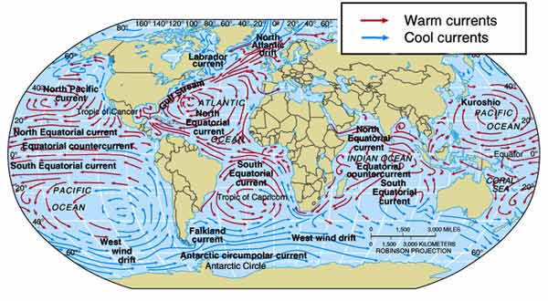
Friction from surface winds drives the global ocean surface currents. These huge flows of water have an enormous impact on regional climates as they transport heat poleward, and return cool water back to the tropics. The largest ocean circulations are huge gyres in the major ocean basins centered on sub-tropical High pressure centers as shown below.
Remember earlier, when discussing the global temperature map (Chapter 3 -> Temperature), we noted differences between the Australian and South American sides of the South Pacific Ocean? The surface current map shows this same phenomenon in more detail. An enormous gyre in the South Pacific sends warm water poleward near Australia and cool water equatorward along South America. As a general rule, remember that ocean current direction matches surface wind direction, and that gyres transport heat poleward on the western sides of ocean basis and return cool water equatorward on the eastern sides of ocean basins. This circulation helps redistribute heat from the tropics to the polar areas as discussed in Chapter 3 > Balance.
