THE NATURAL ENVIRONMENT
Geography 101
ToC
WIND
Forces
Motion
Global
Local
Air Motion
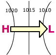
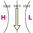
The forces discussed in the previous section act together to produce the horizontal resultant wind direction as shown in the diagram below for the Northern Hemisphere. The pressure gradient force (PGF) sets air in motion from High toward Low pressure. Coriolis deflects that moving air to the right of the direction of motion. Imagine standing on the High center, facing the Low center. Now hold out your right hand; it will point in the direction of Coriolis deflection. In the upper atmosphere, PGF and Coriolis balance to cause wind to blow parallel to the isobars, as shown in the middle panel.
 |
 |
 |
Pressure Gradient Force |
+ Coriolis Force |
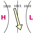
+ Friction = Resultant Wind |
|
|
BOX 1 |
At the surface friction counteracts the Coriolis force somewhat making the resultant wind (the actual wind direction) flow nearly parallel to the isobars but slightly toward the Low and away from the High as shown in the right-hand panel. With this simple relationship, you can fairly accurately map the surface wind pattern from an isobaric map. Just remember: the wind flows almost parallel to the isobars, but slightly toward lower pressure.
Look at the resultant wind diagram in right-hand panel. Imagine the wind blowing in a circular path around the High pressure center: it would flow in a clockwise direction. Similarly, if you imagine the wind blowing in a circle around the Low center, it would flow in a counterclockwise direction. That is true in the Northern Hemisphere. In the Southern Hemisphere, the situation is reversed: wind blows counterclockwise around High pressure and clockwise around Low pressure centers.
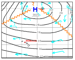
 For example, look at a portion
of the Pacific weather chart from the previous section, Forces.
Blue arrows show wind direction (arrowheads have been added
for clarity). The wind blows clockwise and nearly parallel to the isobars,
but at a small angle away from the High pressure center, exactly as shown
in the resultant wind diagram. This is
typical Hawaiian weather: High pressure to the north causing winds from
the east-northeast in the vicinity of the Hawaiian Islands. Notice that the winds
form
a circular pattern around the High pressure center with winds to the east
of the High blowing in the opposite direction of winds to the west.
Pressure systems, then, produce predictable wind patterns; the most obvious being circular winds around pressure centers as shown in the adjacent diagram using typical isobar values. Angles between wind direction and the isobars are exaggerated to better illustrate how air spirals outward  from High pressure centers and inward toward Low pressure centers. Notice how the wind direction between the pressure centers is consistent; for example, in the Southern Hemisphere, air spirals counterclockwise out of the High system into a clockwise swirl around the adjacent Low.
An old adage for mariners called Buys-Ballot's law states: "In the Northern Hemisphere, if you stand with your back to the wind, the low pressure area will be on your left." This simple expression helped sailors avoid low pressure storms like hurricanes. Imagine standing between pressure centers in the upper diagram to visualize why this law is valid. How would Buys-Ballot be stated for the Southern Hemisphere or for High pressure systems?
Finally, it is important to note that winds near the center of Highs are calm or nonexistent, while the center of Lows may experience strong winds. This feature explains the hot, windless days Hawai'i experiences when a High center moves over the state and the very strong winds found near the center of Low pressure cyclones.
Vertical Air Motion
Another important aspect of the airflow around High and Low pressure centers is the vertical movement of the air, usually occurring at much lower speed than horizontal wind. At Low pressure centers, air rises. At High pressure centers, air sinks toward the surface.
At surface Highs, also called ridges, wind spirals slightly outward, away from the center as shown above. This outward flowing air at the surface pulls the overlying air downward causing descending, or sinking, motion near High centers. The opposite is true of Low pressure areas, also called troughs. Wind spirals slightly inward toward the center at the surface and then vents upward, producing ascending, or rising, motion.
Pressure systems with rising and and sinking air can form in response to surface temperature. Over warm surface areas, the air heats, expands, and rises. This process can initiate a Low pressure trough. The opposite is true of Highs. Over cold surfaces the air cools, contracts, and draws overlying air downward to form a High pressure ridge. Over land areas this relationship is especially obvious. Midlatitude continental areas, such as central Asia and North America, become very cold in winter. The cold contracting air can raise barometric pressure to 1050 mb or more and produce the very strong Highs that dominate winter weather in these areas. The opposite is true in summer when surface warming causes air to expand and form Low pressure centers. Over Asia, the seasonal reversal of surface temperature and pressure drives the monsoon wind system.
Surface temperature does not always determine the overlying air pressure, however. The Hawaiian High pressure system for example, commonly present northeast of the Islands, is caused by the overall circulation of the atmosphere, which we will discuss in the next section.
 |
|
Vertical Motion over Surface High Pressure |
Vertical Motion over Surface Low Pressure |
|
|
BOX 2 |
The diagrams above summarize vertical motion of air over surface pressure systems and typical sky conditions for each.
Look at the Low pressure center. Air spirals in toward the center at the surface and then rises. As air rises, it cools, clouds form, and rain is possible. This diagram generally describes all low pressure systems, including thunderstorms, hurricanes, and midlatitude cyclones. The relationship is discussed further in Chapter 5.
The opposite occurs at High pressure ridges, where air sinks toward the surface and flows outward from the center. When air sinks, few clouds form and clear skies prevail. The Hawaiian Islands lie in an area usually dominated by High pressure and thus skies are generally clear with only scattered clouds.
In the next section, we look at overall wind and pressure patterns for the entire Earth.