THE NATURAL ENVIRONMENT
Geography 101
ToC
WEATHER
Lifting
Air Mass
Fronts
Hurricane
Hawaii
Air Masses
|
|
BOX 1 |
Most short-term changes in midlatitude weather are caused by the movement of air masses. Air masses are huge blobs of air, perhaps thousands of kilometers across, with relatively uniform temperature and moisture content. The recognition of their existence revolutionized weather prediction.
Air masses form over large, relatively homogeneous surfaces and take the characteristics of that surface. Oceans cover most of the Earth and are the source of high-moisture marine air masses. Warm oceans spawn mT (marine Tropical) air masses, while cold oceans produce mP (marine Polar) air. Over continents, where evaporation is limited, dry continental air masses form, including warm, dry cT (continental Tropical) air and cold, dry cP (continental Polar) air. The basic air masses are summarized below.
Four Basic Air Masses |
Moisture |
||
marine (m) |
continental (c) |
||
Temperature |
Polar (P) |
mP (moist, cold) |
cP (dry, cold) |
Tropical (T) |
mT (moist, warm) |
cT (dry, warm) |
|
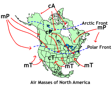
An example of the source regions for various air masses and their movement is shown in the diagram of North America (cA refers to continental Arctic, somewhat colder and drier than cP air).

Consider the weather report: "Mideast in a deep freeze!" That happens when cP (or cA) air drops down into the US from central Canada where it formed, and then travels toward the East Coast on the westerly winds. How about, "New England buried in snow by nor'easter!"? Wet, cold mP air from the North Atlantic has been pushed ashore by a high pressure center further to the north. Summer thunderstorms in the Southeast? mT air off the Gulf of Mexico. Heat wave in the Midwest? cT air off the deserts of Mexico and the American southwest.
You can see why being able to identify an air mass and predict its direction of movement helped revolutionize weather prediction. If you know that a cT air mass is headed your way, you can expect hot, dry conditions. If an mT air mass is coming in summer, expect hot, muggy weather with possible thunderstorms. Understanding the movement of the boundaries where air masses meet is even more useful to the forecaster. These boundaries are called fronts and are discussed in the next section.