THE NATURAL ENVIRONMENT
Geography 101
ToC
WEATHER
Lifting
Air Mass
Fronts
Hurricane
Hawaii
WEATHER PATTERNS from MIGRATORY LOWS
 Migratory
midlatitude low pressure systems, also called midlatitude cyclones, travel
in the opposite direction of the trade winds, moving from west to east
in the westerly wind belts. The circulation around
these low pressure centers
drags cold air equatorward and forces warm air poleward helping transfer
heat to higher latitudes. At the boundary of these huge air masses, fronts form;
typically a powerful cold front to the southwest and a weaker warm front
to the east.
The Hawaiian High pressure center can usually block these systems, but if it
weakens or moves, the cold front trailing south of the low center may
sweep the islands. Typically in the cool season, November through April, about
15 cold fronts pass over Kaua'i and about
9 of these reach the Big Island. Fronts cause some of the most destructive Hawaiian
weather.
 Cold
Fronts: "FORECAST: increasing cloudiness, decreasing
pressure, winds shifting from southwesterly to northerly, temperature dropping,
widespread rainfall locally heavy, chance of thunderstorms and flash flooding."
Rapid weather changes are the hallmark of fronts. The front is a transition
between air masses, so a typical sequence would be: warm air mass conditions,
heavy weather at the transition, cold air mass conditions. In the warm
sector ahead of the front, an area would experience light winds
from the south, humid conditions, and relatively clear skies. As the front
sweeps past, the forced lifting of air could produce deep clouds and rainy
weather. Some of Hawai'i's worst weather has been the
result of a vigorous frontal passage. An example would be the New Year's
Eve flooding of 1987. Up to 500 mm (20 inches) of rain fell on parts of East O'ahu
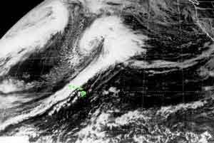
in just a few hours. After the front passes, cold air mass conditions prevail, dominated by a migratory High (see the clear
area to the west of Hawai'i in the satellite image above?). Winds
turn northerly, temperature drops, and the skies clear.
Warm Fronts: "FORECAST:
Increasing cloudiness with a chance of light showers, winds turning southerly,
with temperatures increasing."
The difference in temperature between air masses at a warm front in the
vicinity of Hawai'i is generally very small and extreme
weather is rare. Most warm fronts pass to the north of the Islands, but they ocassionally move far enough south in the cool season to cause increased cloudiness and light rain,
followed by hot, humid weather and southerly winds.
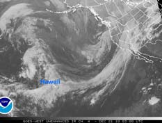
Shear Line: "FORECAST: cloudy skies, widespread rainfall possible, highs near 25° C (upper 70's °F), lows near 20° C (upper 60's °F), variable winds." If the migratory low is far away to the northeast, the cold front's long tail may touch the Islands bringing overcast skies and light rainfall. Because the temperature contrast between air masses is minimal, however, shear lines seldom produce violent weather. If the distant low is over the west coast of North America, it may bring miserable, wet weather to California and Oregon as tropical moisture is pumped east and north into the system. On the mainland, this configuration is called the "Hawaiian Express" or the "Pineapple Express" as the trailing end of the cold front is often in the vicinity of Hawai'i as shown in the image.
|
BOX 1 |