
THE NATURAL ENVIRONMENT
Geography 101
ToC
WEATHER
Lifting
Air Mass
Fronts
Hurricane
Hawaii
WEATHER PATTERNS from LOWS WITHOUT FRONTS
 Low
pressure systems without fronts include
Kona storms, tropical depressions, tropical storms and hurricanes. These potentially
hazardous systems form in tropical air masses and have no fronts because they do not bring warm
and cold air into contact. They are simply counterclockwise
circulations with rising air.
As air rises, it cools, clouds form, and heavy rainfall and flooding
are possible.
Unlike high pressure centers, which generally have very light winds, low pressure centers may generate extremely high wind speeds.
For these reasons, sailors prefer to avoid the centers of both
highs, with no wind, and lows, with too much wind.
Low
pressure systems without fronts include
Kona storms, tropical depressions, tropical storms and hurricanes. These potentially
hazardous systems form in tropical air masses and have no fronts because they do not bring warm
and cold air into contact. They are simply counterclockwise
circulations with rising air.
As air rises, it cools, clouds form, and heavy rainfall and flooding
are possible.
Unlike high pressure centers, which generally have very light winds, low pressure centers may generate extremely high wind speeds.
For these reasons, sailors prefer to avoid the centers of both
highs, with no wind, and lows, with too much wind.
 Kona
storms: "FORECAST: Overcast skies, with
occasionally heavy rainfall affecting all islands, highs near 25° C (upper 70's °F),
lows near 18° C (mid-60's °F), southerly winds gusting to 55 kph (34 mph)." Kona storms, or Kona Lows,
form in the cool season of November through April from the tail end of
dying midlatitude lows, as shown in the satellite image, or from an
upper tropospheric disturbance. These rare events are odd weather creatures called "cold-core lows" that wander slowly on often unpredictable
paths and linger for a week or more. Winds may be strong or
light. Rainfall may be continuous or intermittent although skies are generally
completely overcast. In severe cases, Kona storms have caused terrible
weather, including hailstorms, thunder and lightning, waterspouts, torrential
rains,
high surf, and flooding. Generally, the rainiest weather occurs when the
Low forms to the west of the Islands, as in the satellite image above. If the
low forms east of the Islands, rain may miss Hawai'i altogether, but
winds
may be strong. Kona storms should not be confused with mild Kona weather, described in the High pressure section.
Kona
storms: "FORECAST: Overcast skies, with
occasionally heavy rainfall affecting all islands, highs near 25° C (upper 70's °F),
lows near 18° C (mid-60's °F), southerly winds gusting to 55 kph (34 mph)." Kona storms, or Kona Lows,
form in the cool season of November through April from the tail end of
dying midlatitude lows, as shown in the satellite image, or from an
upper tropospheric disturbance. These rare events are odd weather creatures called "cold-core lows" that wander slowly on often unpredictable
paths and linger for a week or more. Winds may be strong or
light. Rainfall may be continuous or intermittent although skies are generally
completely overcast. In severe cases, Kona storms have caused terrible
weather, including hailstorms, thunder and lightning, waterspouts, torrential
rains,
high surf, and flooding. Generally, the rainiest weather occurs when the
Low forms to the west of the Islands, as in the satellite image above. If the
low forms east of the Islands, rain may miss Hawai'i altogether, but
winds
may be strong. Kona storms should not be confused with mild Kona weather, described in the High pressure section.
 Tropical Cyclones : "FORECAST: Find shelter!
Wind gusts of more than 160 kph (100 mph), torrential rainfall, extremely high surf
and storm surge
possible." Hawai'i's most devastating storms are infrequent,
but may affect the Islands from June though mid-November. Under favorable
atmospheric conditions, these intense storms can strengthen to form the
familiar spiral cloud bands and central eye. The most intense weather
occurs
near the eye
wall, and hurricane force winds are generally confined to an 80 to 160 km (50 to 100 mile)
radius. Tropical depressions (winds up to 63 kph (39 mph)) and tropical storms (63-119 kph (39-74 mph)) affect the island more frequently than hurricanes,
either representing dying hurricane systems or low pressure centers that
did not strengthen into hurricane force. These systems normally approach from the east or south and can bring heavy rainfall
and thunderstorms as they temporarily displace the trade-wind inversion.
Tropical Cyclones : "FORECAST: Find shelter!
Wind gusts of more than 160 kph (100 mph), torrential rainfall, extremely high surf
and storm surge
possible." Hawai'i's most devastating storms are infrequent,
but may affect the Islands from June though mid-November. Under favorable
atmospheric conditions, these intense storms can strengthen to form the
familiar spiral cloud bands and central eye. The most intense weather
occurs
near the eye
wall, and hurricane force winds are generally confined to an 80 to 160 km (50 to 100 mile)
radius. Tropical depressions (winds up to 63 kph (39 mph)) and tropical storms (63-119 kph (39-74 mph)) affect the island more frequently than hurricanes,
either representing dying hurricane systems or low pressure centers that
did not strengthen into hurricane force. These systems normally approach from the east or south and can bring heavy rainfall
and thunderstorms as they temporarily displace the trade-wind inversion.
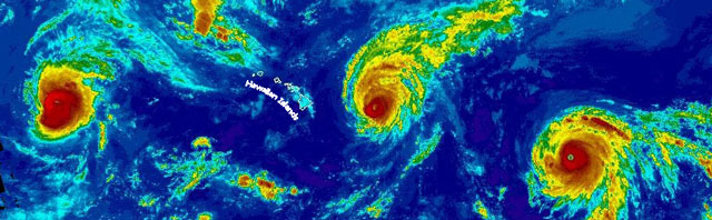
The Hawaiian Islands have experienced secondary effects of hurricanes, such as swells, storm surge, and heavy rainfall, quite often, but direct hits by hurricane force winds are rare. During the hyperactive El Nino season of 2015, hurricane after hurricane took aim at Hawai'i and then either skirted the Islands or weakened before arriving. There were so many hurricanes that meteorologists were comparing the false color satellite images to a real-life Van Gogh's "Starry Night" painting. The trio of Kilo, Ignacio, and Jimena (below) was the first time that three Category 4 hurricanes were seen in the Pacific at the same time. None of them caused any significant damage in the state.
|
BOX 1 |