THE NATURAL ENVIRONMENT
Geography 101
ToC
EROSION
Wind
Waves
Coasts
Glaciers
Erosion by Ice
|
|
BOX 1 |
The most powerful erosive force of all is moving ice. When a kilometer-thick ice sheet rumbles over the land, mountains move. When millions of tonnes of glacier grind downhill, valleys widen.
 The
amount of ice on land grows and shrinks with the global climate, which
changes fairly rapidly in geologic time. Twenty thousand years ago, about
30% of Earth's land area was covered with ice.
Today, that figure is only 10%. Many of the landforms we see today were carved
during earlier, colder periods in Earth's history. Most of the past
two million years, in fact, have been much colder than today's climate.
Geologists call that two million year period the Pleistocene Epoch. The Pleistocene was a time of widely fluctuating temperatures, with both cold glacial and warmer interglacial periods, as shown in the diagram. The Pleistocene ended 10,000 years ago with rapid global warming, the melting of huge continental ice sheets and a corresponding rise in sea level. Since then, we have been in the warmer Holocene Epoch. In reality, the Holocene is probably just another interglacial period and we should expect the next deep-cooling glacial period to begin within a few thousand years, assuming that human-caused global warming does not interfere with the natural cycle.

The figure above shows sea level changes, not global temperature changes, but the two are interlinked. During glacial periods, ice accumulates on land and sea levels drop as water transfers from oceans to land. Then, during warmer interglacials, large expanses of ice melt adding water to the global ocean and raising sea levels.
Large ice formations are categorized as:
- Continental ice sheets cover hundreds of thousands of square kilometers and are up to three kilometers thick. Two ice sheets remain, one covering Greenland and the other covering Antarctica. At one time, however, ice sheets covered most of North America, Northern Europe, and Northern Asia.
- Highland ice fields, or continental glaciers, form in high mountain basins and submerge all topography except the highest mountains. These are common in Western Canada, Southern Alaska, and Iceland, and may produce many smaller glaciers flowing out of mountain passes.
- Alpine glaciers are small individual glaciers streaming down the sides of high mountains. They make up only a small portion of the total ice reservoir, but are the most familiar large ice formation.
Erosion
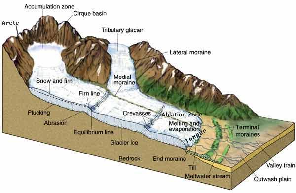
Glaciers result from the buildup of snow. As the snow deepens, the lower layers under pressure gradually recrystallize into solid ice. When the ice thickens enough, the lower layers become plastic and flow, carrying the entire glacial mass downhill. The upper, colder reaches of the glacier are called the accumulation zone. This is the source area for glacial ice. The lower, warmer end of the glacier, which loses ice by evaporation and melting, is called the ablation zone. The very end of the glacier is called the tongue. If ice in the ablation zone is melting faster than the glacier is moving downhill, the tongue will move uphill and the glacier is said to be retreating. If the glacier is moving downhill faster than the ablation zone and tongue are melting, the glacier is said to be advancing.

 As
the ice moves, it erodes the surface largely by abrasion.
Chunks of rock become frozen into the base of the glacier (a process
appropriately called plucking) and act as powerful sandpaper that scrapes
and
pulverizes bedrock. Abrasion leaves a relatively smooth surface, often marked
with parallel grooves called glacial striations.
Glacial erosion creates distinctive landforms. The accumulation zone becomes gouged out into a bowl-like depression called a cirque. Cirques may meet at knife-edged ridges called arêtes or flow outward from an isolated mountain carving out a pyramid-shaped peak called a horn, such as Switzerland's famous Matterhorn.

 As
the glacier moves downhill it gouges out U-shaped
valleys.
These are easily recognizable and distinct from the V-shaped valleys
carved by running water. Sea level rise during interglacial periods may
flood the U-shaped valley, creating long, narrow inlets of the sea
called fiords.
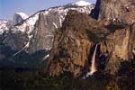
As a glacier widens a river valley, it may remove the valleys of small side streams, leaving the streams to empty directly down the newly-carved, steep walls creating a hanging waterfall,
such as Bridal Veil Falls in Yosemite Valley.
As
the glacier moves downhill it gouges out U-shaped
valleys.
These are easily recognizable and distinct from the V-shaped valleys
carved by running water. Sea level rise during interglacial periods may
flood the U-shaped valley, creating long, narrow inlets of the sea
called fiords.
As a glacier widens a river valley, it may remove the valleys of small side streams, leaving the streams to empty directly down the newly-carved, steep walls creating a hanging waterfall,
such as Bridal Veil Falls in Yosemite Valley.
Deposition
Glacial drift is a general term for the pulverized rocks and other debris left behind by moving glaciers. Drift deposits at the end and sides of glaciers are called moraines, as shown in the diagram above. They include terminal moraines (which mark the farthest advance of the tongue), lateral moraines (along the sides), and medial moraines (marking where two glaciers met and flowed side by side).
 Glaciers
and ice sheets may carry rocks hundreds of kilometers from their source area.
When the ice melts, these rocks are left
in areas they do not match geologically. Large boulders thus deposited
are called glacial erratics. Tens of thousands of erratics
excavated from the Canadian Shield were carried southward and dropped
off in what
is now the United States.
Hawai'i
Although Hawai'i does not evoke images of glaciers, during the Pleistocene Epoch, Mauna Kea and Mauna Loa were topped with caps of ice. Many relic landforms from several periods of glaciation exist at the summit of Mauna Kea. Mauna Loa has been so volcanically active that lava flows have obliterated any glacial features that may have once existed.
 |
 |
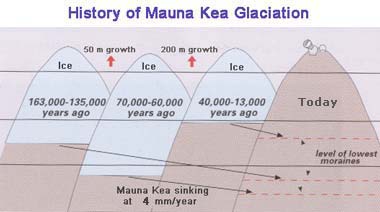
The figure shows the most prominent glaciation episodes on Mauna Kea. Terminal moraines identify the lowest levels of the glaciers. Because the Big Island is slowly sinking at about 4 mm/year, the terminal moraines are found at lower elevations today than when they formed. Many glacial features exist on Mauna Kea, including glacial striations, moraines, and glacial erratics. The photograph shows a terminal moraine above Pohakuloa State Park in the Saddle area. Note how flat the mountain has been scraped above the V-shaped terminal moraine.
During these cold periods, change was not confined to the summit of Mauna Kea. 21,000 years ago, for example, sea level was about 100 meters (300 feet) lower than today. This exposed land bridges connecting Maui, Lana'i, and possibly Moloka'i, and produced wave-cut notches and terraces below today's sea level. Evidence from pollen analysis suggests that Hawaiian vegetation zones moved to lower elevations in response to cooler temperatures. The koa zone, for example, which today dominates between 1600 and 2100 meters (5000 and 7000 feet), dropped down to 500 to 1100 meters (1500 to 3600 feet). An analysis of pollen, soils, and erosional features suggests that the climate was slightly wetter at low elevations but drier between 1000 and 2000 meters (3000 and 6000 feet) during colder periods.The lower mountain dry zone may have been the result of a lower average altitude of the trade wind inversion.