THE NATURAL ENVIRONMENT
Geography 101
ToC
CLOUDS
Evap
Humidity
Stability
Condense
Clouds
Clouds
|
|
BOX 1 |
Cloud watching, from children looking for animals in cloud shapes to the meteorologist studying weather patterns in satellite images, is an international pastime. Both observations, the whimsical and the analytical, try to interpret one of nature's most complex phenomena.
Even a basic classification of these continuously shifting shapes eluded humanity for millennia until about 200 years ago when amateur meteorologist Luke Howard proposed one. His basic cloud designations are still in use.
Cloud Types
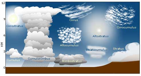
Most clouds can be classified as combinations of just five words: cirrus (referring to high-altitude, and sometimes wispy), alto (referring to mid-altitude), cumulus (individual puffy), stratus (continuous layer), and nimbus (meaning precipitating). Look at the chart below and see how these words are used by themselves and in combination to describe ten basic cloud types. Notice the difference in the sun's appearance seen though cirrostratus and altostratus clouds: cirrostratus often produces a ring-shaped halo around a bright sun, while the thicker altrostratus reduces its appearance to dull glow. You may also see a halo around a full moon at night when cirrostratus clouds are present. Also note that the huge, thunderstorm-producing cumulonimbus clouds can fill the entire depth of the troposphere and range from liquid water at the bottom to ice crystals at the top.

 The altitude designations represent the
different states of water in the atmosphere. Below about 2 km (1.2 mi),
clouds consist mostly of liquid water droplets. Above about 6 km (4 mi),
cirrus clouds consist
mostly of ice crystals, and in between alto clouds are a mixture of both
ice and liquid water.
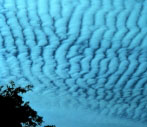
 Altocumulus
(mid-altitude puffy) clouds sometimes form a fish-scale pattern called a mackerel sky, as shown at
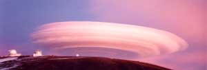
left. And if you see a flying saucer floating over a tall Hawaiian
mountain, don't be alarmed; it's just a lenticular cloud, such as this
one over Mauna Kea. These form at mountain tops under
very stable conditions with high winds.
Air squeezes over the summit and creates these eerily distinct clouds.
Fog
Fog is simply a cloud that touches the ground. Fog forms in many ways, including:
Radiant Cooling |
In cool climates, the ground may become extremely cold under clear skies at night when heat is lost through radiation cooling. The cold ground cools the air above it and a shallow layer of fog may form. In mountainous areas, cool air may collect in valleys and produce a "puddle" of fog. |
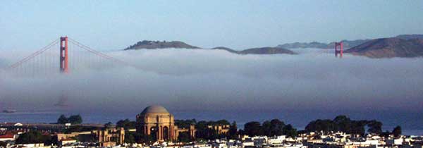
Advection Cooling |
Think San Francisco. The water by the shoreline is very cold, so when warmer air from farther out to sea is drawn toward land over the cold shore water, it cools to the dew point and fog rolls into the Bay. |
Orographic Cooling |
When wind blows into a mountain, air is forced to rise and cool. If it cools to the dew point, fog forms along windward slopes. This is the most common type of fog in Hawai'i, but it is often referred to as cloud, as in the expression "cloud forest." |
Evaporation Fog |
This is equivalent to a steaming cup of coffee. If cold air overlies warm water, evaporation from the warm water greatly increases the vapor pressure. When the vapor pressure increases to the saturation vapor pressure of the cooler air, fog forms. |
