THE NATURAL ENVIRONMENT
Geography 101
ToC
MAPS
Geography
Size
Latitude
Longitude
Time
Maps
New Tools
Latitude
The geographic grid refers to the spherical coordinate system of latitude and longitude used to locate positions uniquely anywhere on Earth's surface. These coordinates are given as angles, rather than distances as used in more familiar rectangular coordinate systems. Angles are measured in degrees, minutes and seconds, in which 60 seconds = 1 minute, and 60 minutes = 1 degree. By convention, the symbol ° is used to represent degrees, the symbol ' to represent minutes, and the symbol " to represent seconds. As an example, the latitude of Aloha Tower in Honolulu is of 21° 18' 25.6" N, meaning 21 degrees, 18 minutes, and 25.6 seconds North latitude.
|
|
BOX 1 |
Latitude is defined as the angular distance from the center of the Earth to a position north or south of the equator. Values range from 0° at the equator to 90° north at the North Pole, and to 90° south at the South Pole. All latitude lines form complete circles, which are also called parallels. Equator, North Pole, and South Pole are all names of specific parallels of latitude.
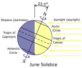
Other important parallels are the Tropic of Capricorn (23.5° south), Tropic of Cancer (23.5° north), Antarctic Circle (66.5° south), and Arctic Circle (66.5° north). These latitudes are defined by the angle at which the sun's rays fall on Earth at different times of year.
 At June
solstice, about 21 June, the noontime sun is directly
overhead at 23.5° north, the Tropic of Cancer,
as shown in the diagram. At December
solstice, about 21 December, the noontime sun is directly
overhead at 23.5° south, the Tropic of Capricorn.
Being directly overhead means that no shadow is cast by vertical surfaces or objects, such as telephone poles and fence posts.
The tropics are defined, then, as the area of Earth's surface where the
sun is directly overhead at some point during the year. In Hawai'i,
those days are sometimes called Lahaina Noon because
the sun is blazingly intense. For O'ahu, at about 21° north, Lahaina
Noon occurs on
about May 26 and July 16.
Also at June Solstice, all areas north of the Arctic Circle experience continuous, 24-hours-a-day direct sunlight and all areas south of the Antarctic Circle experience continuous darkness. The situation is reversed at December Solstice. The diagram illustrates why. Notice that the North Pole (the big N at the top of the diagram) is tilted toward the sun and the entire area north of the Arctic Circle is sunlit, shown in yellow in the diagram. Notice too, that the entire area south of the Antarctic Circle is in darkness, shown in blue in the diagram. All other latitudes include both sunlit and shadowed areas. The Arctic and Antarctic Circles then, define the lowest latitudes at which areas experience both continuous daylight and continuous darkness at some point during the year.
