THE NATURAL ENVIRONMENT
Geography 101
ToC
MAPS
Geography
Size
Latitude
Longitude
Time
Maps
New Tools
Time
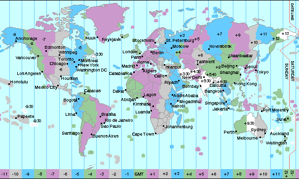
Time zones are another arbitrary societal choice, like the origin point of the Prime Meridian. They are based on longitude and defined by Earth's rotation, which completes a full circle (360 degrees) each day (24 hours). Each hour then, Earth rotates through 360/24 = 15° of longitude: the width of one time zone. For continuity in human experience -- meaning that wherever you go on Earth, the sun is near its highest point in the sky at noon -- the nations of the world agreed upon a flexible system of time zones. Each time zone is 15 degrees wide, but some are stretched in various ways to accommodate political boundaries, as shown below.

|
|
BOX 1 |
The bottom scale on the figure gives the hour difference between the reference time zone centered on Greenwich and locations around the world. An important point to note in the figure is that, for any location, places to the east have a later time, and places to the west have an earlier time. For example, compared to Los Angeles, the time in New York, to the east, is later, while the time in Honolulu, to the west, is earlier. Remember: eastward is later, westward is earlier.
These rules apply to any location on earth and refer just to the time, not the day - the day has different rules that include reference to the International Date Line (IDL). Remember from the Longitude section that when you move westward across the IDL the day moves ahead (Friday becomes Saturday) and when you move eastward across the IDL, the day moves back (Saturday becomes Friday).
 Today, every cell phone can tell you the longitude instantly, but historically, finding your meridian was one of the most vexing
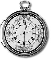
problems in the long history of navigation. It was not until the invention of an accurate portable chronometer that the problem was solved by using the relationship between time and longitude. The first of these devices, from English inventor John Harrison,
is shown in the image. To find the longitude, simply compare your local time with the time at a known location and multiply by 15 °/hr. For example, if your local solar time differs from another location by 4
hours, then
you are
4 x
15 = 60° longitude
away
from that location.
Let's look at a more detailed example: say your clock is set to the time at 0° longitude, called Coordinated Universal Time (UTC) or Greenwich Mean Time (GMT). You take very accurate measurements of the sun's movement and determine that it reaches its highest point in the sky (noon at your location) when your UTC clock reads 2 pm. The time difference between 0° and your location is 2 hours, noon to 2 pm. Since each hour represents 15°, you are 2 x 15 = 30° away from 0° longitude . Further, you know that 0° is east of your location because your UTC clock reads later than your local time by 2 hours. Remember, the time at locations to the east are later. 0° is east of your location meaning that you are west of 0°. So: starting at 0° and moving 30° westward gives your longitude as 30° west. It will be helpful to sketch this scenario on paper to visualize the relationship and to review the summary table of this example below.
Summary of finding longitude using time difference example |
|
| time at your location | 12 pm (noon) |
| time at 0° (Greenwich) | 2 pm |
| time difference | 2 hours |
| longitude difference | 2 hours x 15°/hr = 30° |
| are you E or W of 0°? | West because Greenwich time is later |
| your longitude (reference +/- difference) | 30° west of 0° = 30°W |
If Greenwich time (UCT) is 10 am when it is noon at your location, what is your longitude? _________
If Greenwich time (UCT) is 10 pm when it is noon at your location, what is your longitude? _________