THE NATURAL ENVIRONMENT
Geography 101
ToC
MAPS
Geography
Size
Latitude
Longitude
Time
Maps
New Tools
Longitude
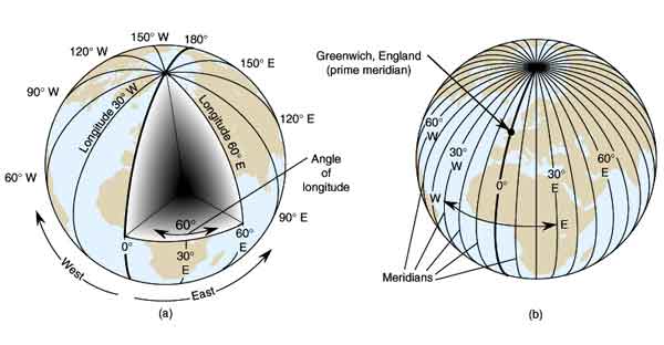
Longitude lines (also called meridians) run perpendicular to latitude lines and form half-circle arcs between the North and South Poles. They are defined by the angle from the Earth's spin axis to a point east or west of the Prime Meridian at 0° longitude as shown below. Unlike latitude, which has a natural origin parallel of 0° at the Equator, longitude has no natural reference meridian. Over the centuries, dozens of 0° reference meridians were used by various nations, but as global connections in trade, surveying, navigation, and timing grew, trying to coordinate all of the different systems became unmanageable. Ultimately, the nations of the world held a conference in 1884 and agreed to accept the widely-used English reference, centered on the Greenwich Observatory in Greenwich, England, as the international Prime Meridian.

Values of longitude increase from 0° at the Prime Meridian to 180° both westward and eastward as shown in the diagram. 180° longitude is known as the International Date Line (IDL) and it bisects the Pacific Ocean touching almost no land. The Prime Meridian and the International Date Line, then, are both names of specific meridians of longitude.
|
|
BOX 1 |
The International Date Line is an artifact of the global time system which, by international agreement, forms the beginning and ending point of each day. In Fiji, just west of the IDL, the national paper carries the motto "The First Newspaper Published in the World Each Day." If you cross the Date Line moving westward (from Hawai'i toward Asia), you move ahead one day (Monday becomes Tuesday). If you cross the Date Line moving eastward (from Asia toward Hawai'i), you move back one day (Tuesday becomes Monday). The relationship between time and longitude is discussed more fully in the next section.
Geographic coordinates, then, are latitude-longitude pairs given in angular units of degrees, minutes, and seconds. The latitude is always given first and the longitude second. Latitude coordinates will almost always include an N (for north of the equator) or S (for south of the equator) and longitude will almost always include an E (for east of Greenwich) or W (for west of Greenwich). Exceptions are 0° latitude and 0° and 180° longitude, which do not have a letter attached to them. As an example, Aloha Tower in Honolulu is 21° 18 ' 25.6" N latitude, 157° 51' 57.6" W longitude. If you ever need to estimate distance using geographic coordinates, note that one minute of latitude at Earth's surface defines one nautical mile, equaling exactly 1852 meters or about 1.15 statute (familiar) miles.
Refresh your memory and practice finding latitude
and longitude for various places on the grid map below. Fill in coordinates for the colored circles using numbered scales at the edge of the map. Be sure to include the hemisphere designation (N, S, E or W). Do not turn in your answers, it is for practice only.
|
LOCATION 1. Greenwich England (red dot) |
LATITUDE _______________ |
N/S __ |
LONGITUDE _______________ |
E/W __ |