
THE NATURAL ENVIRONMENT
Geography 101
ToC
MAPS
Geography
Size
Latitude
Longitude
Time
Maps
New Tools
New Tools
 Geography has been at the forefront of the digital revolution
in mapping. Huge advances have been made in the collection of map data
(Remote Sensing), finding location (Global Positioning System), and the
analyses and display of map information (Geographic Information Systems).
Geography has been at the forefront of the digital revolution
in mapping. Huge advances have been made in the collection of map data
(Remote Sensing), finding location (Global Positioning System), and the
analyses and display of map information (Geographic Information Systems).
Remote Sensing
|
|
BOX 1 |
The name is fully descriptive of the method: remote sensing means collecting information at a distance. Certainly you have seen satellite weather images? These are remotely sensed from space. Satellites collect data over many wavelengths and provide instant maps of ocean temperature, atmospheric water vapor content, vegetation health, plankton density, and thousands of other features. In the Big Island image, for example, vegetation cover is shown as shades of red.
Your digital camera is a byproduct of research that developed remote sensing technology. In fact, photography is a form of remote sensing. And a very useful one. Aerial photos from planes have long been used as baselines for mapping. Hand held cameras on the Space Shuttle provide not only beautiful photos, but valuable data as well.
Remote sensing provides raw information as a basis for specific map uses.
Global Positioning System (GPS)
The most widely used global positioning system is an orbiting network of satellites maintained by the US Department of Defense, but several other countries maintain satellite navigation networks as well. Using GPS signals, your phone can locate positions to within about 5 meters (16 feet), but much greater accuracy is available using multi-band receivers and paired GPS units.
 GPS
has thousands of uses. Cars have them installed to provide
route information. Train authorities
track locomotives to reduce accidents. Ships use them to navigate into
harbors and plot routes. Demolition experts on Kaho'olawe use it to record
the location of unexploded bombs. Archeologists use it to map ancient
Hawaiian sites. Surveyors use it to location property boundaries. And, of course, cell phone locations have a seemingly infinite number applications.
GPS
has thousands of uses. Cars have them installed to provide
route information. Train authorities
track locomotives to reduce accidents. Ships use them to navigate into
harbors and plot routes. Demolition experts on Kaho'olawe use it to record
the location of unexploded bombs. Archeologists use it to map ancient
Hawaiian sites. Surveyors use it to location property boundaries. And, of course, cell phone locations have a seemingly infinite number applications.
The technology is fairly simple conceptually. The receiver records the time it takes for signals from at least four satellites to reach it, and then calculates the distance from each satellite. The point where these distances intersect (a process called triangulation) is the location.
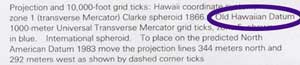 Users of GPS location data must choose a datum to map onto. Datums are mathematical
models developed through geodesy that give a smooth representation of our imperfectly shaped
Earth. Virtually all phones use a datum called World Geodetic System 1984 (WGS84), but other datums also exist. Hawaiian Islands maps generally use
the NAD83 datum, although some older applications still use the venerable 1927 Old Hawaiian Datum. When using a map, you will find the datum information in the legend.
Users of GPS location data must choose a datum to map onto. Datums are mathematical
models developed through geodesy that give a smooth representation of our imperfectly shaped
Earth. Virtually all phones use a datum called World Geodetic System 1984 (WGS84), but other datums also exist. Hawaiian Islands maps generally use
the NAD83 datum, although some older applications still use the venerable 1927 Old Hawaiian Datum. When using a map, you will find the datum information in the legend.
Geographic Information Systems (GIS)
 GIS
has become one of the most widely used software tools in science, government, and the private sector. Map data is converted to digital format and stored
in a large database referenced by location. The database consists
of many layers of data, as shown in the diagram. Each layer represents
a feature. For example, a National Park Service GIS for Haleakala might
include
layers
which
showed topography, silversword density, roads, visitor facilities, research
locations, soils type, rainfall, sunlight intensity, freezing frequency,
landslide hazard, and so on. These layers can be combined in different
ways to answer scientific questions or provide specialized maps. For
visitors,
a map showing roads, topography, and tourist facilities might be useful.
For a silversword expert, a map integrating freezing frequency, soils,
and silversword density might help understand the plants' growth.
GIS
has become one of the most widely used software tools in science, government, and the private sector. Map data is converted to digital format and stored
in a large database referenced by location. The database consists
of many layers of data, as shown in the diagram. Each layer represents
a feature. For example, a National Park Service GIS for Haleakala might
include
layers
which
showed topography, silversword density, roads, visitor facilities, research
locations, soils type, rainfall, sunlight intensity, freezing frequency,
landslide hazard, and so on. These layers can be combined in different
ways to answer scientific questions or provide specialized maps. For
visitors,
a map showing roads, topography, and tourist facilities might be useful.
For a silversword expert, a map integrating freezing frequency, soils,
and silversword density might help understand the plants' growth.
GIS is a fact of life here and elsewhere. Perhaps the most widely used private spatial database is Google Earth and its associated maps. Governments have also embraced the technology for storing information and displaying data to the public.
The City and County of Honolulu offers several thematic maps that draw information from their large GIS database, including Parcel and Zoning Information, Parks, Recycling, and Climate Impacts. They also provide spatial layer data that users can download in several formats. The State of Hawaii also maintains a fairly large GIS data base to access themes such as census data, major landowners, land use, natural resources, aerial images, geodesy and more.